High Country – December 2018
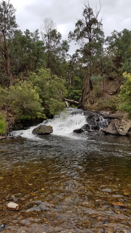
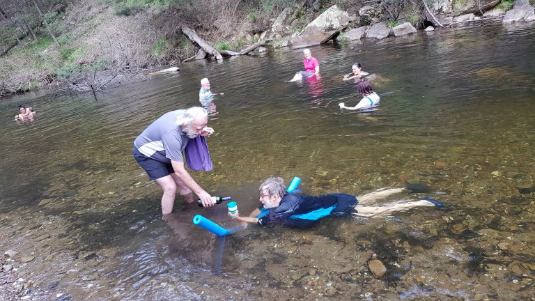
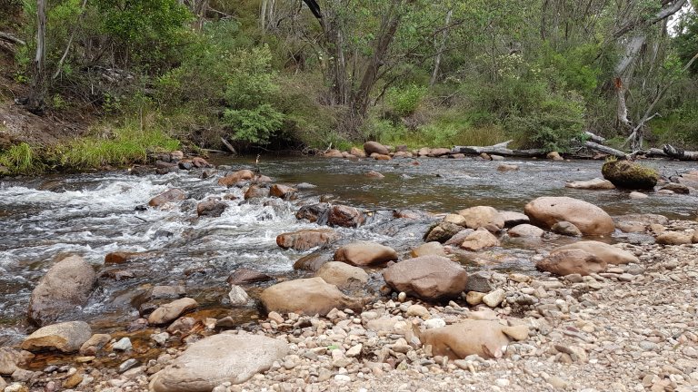
This was the clubs inaugural off road trip. Our first camp, and meeting place, was Black Flat on the Upper Dargo Road, next to the Dargo River. The first thing we all noticed upon our arrival at camp were the cicadas. They were very loud. However, down at the river they could barely be heard. Since it was very hot, we spent a fair bit of the first two days down in the river.
Our first stop on this day trip was Harrison’s Cut (pictured left). This 50m gold diversion sluice forms part of the Dargo River and was created around the 1880’s. It was a popular spot with plenty of visitors during the time we were there.
We engaged low range for an enjoyable climb up and out of the valley via Matheson Spur Track. Views were spectacular once at the top and we noticed a pretty good drop in temperature as we climbed too. Our next stop was Bullock Head Saddle and then Treasures Huts for morning tea. We then went to the historic township of Grant. In the 1890’s there were once over 2,000 people who lived there.
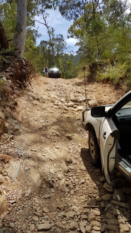
We left Grant and descended Bulltown Spur Track, a very good and steep decent down to the Crooked River. There are 24 river crossings on the Crooked River Track, the majority of which are all very basic. Although the first one we encountered, traveling from north to south (pictured right) was a small challenge for one of the vehicles.
After Crooked River, we drove through the busy campsite at Talbotville and then began our climb up Collingwood Spur Track. The track was dry and dusty and it had clearly had a lot of traffic recently as it was chewed out in spots. The temperature was nudging 38 degrees, and as the vehicles were working hard, we had to be mindful of the temperature gauge. Then it was back to camp for a swim.
The next day we packed up camp and headed up Stock Route Track – an enjoyable but steep climb out the opposite side of the same valley we’d done the day before. We headed to Dog’s Grave for morning tea and the site of the ADA hut. We carried on back via Birregun Road and then turned off onto Messmate Spur Track. We meandered along and next to a river for a while and then a very steep climb with much shale, up Dane’s Link Track. The camping place for the night was Camm’s Top Place. It was initially going to be a late lunch, but it was a lovely place and we had it to our selves we decided to turn it into the nights camp.
The next day we left early (8am). The first challenge was Murdering Spur Track. This was a very steep and rough track. Our destination was Buckwong Hut, via Omeo and Dawson City. Buckwong Hut was very crowded, maybe 30 or more vehicles.
The next day we did a short drive to the Poplars via Buckwong Track and McCarthy’s Track. This very near the begging of the Murry River.
See newsletter #5, February 2019 for the full trip report
Jam making – December 2018
We had a glorious day for berry picking and subsequent jam making. Eight of us turned up to Blue Hills Berry farm to get their sugar rush. The farm had loganberry, youngberry, blackberry, raspberry (3 types) and strawberry. The cost was 13:50 per person which included 500g of fruit and as much as you could eat.
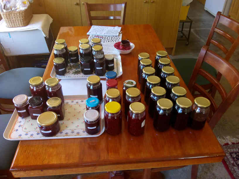
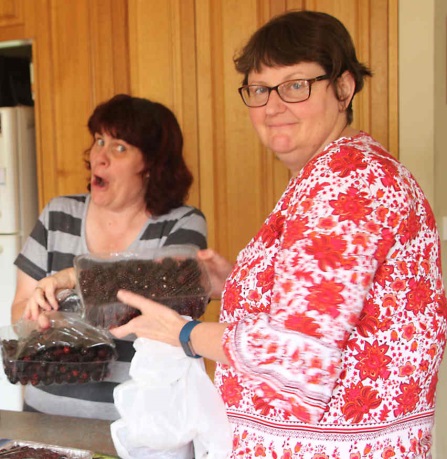
After a few hours of picking, most people had what they needed, so we paid for the extra fruit and then it was off to Sandy and Alan’s place for the jam making.
See newsletter #4, January 2019 for the full trip report
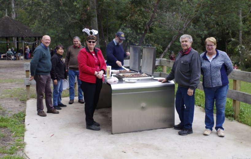
Christmas BBQ – November 2018
This is our first official trip as a club.
Mike and Meredith were up early (6:30 am) to secure a shelter at Cardinia Reservoir. They just got the one they wanted before a couple of others nabed it. The park is very well equipped, with free BBQs (which the club made use of), shelters with some seating and toilets.
The christmas tree was set up to get into the spirit of things. There was a great turnout and fun was had for all.
See newsletter #3, December 2018 for a full trip report
Pre Trip Report – Grampians, Melbourne Cup Weekend
By Michael – Over the Melbourne Cup weekend a few of us went to the Grampians National Park. It was quickly decided that this would be a perfect time for a pre-trip to see what activities would be of interest to the club. While I have been to the Grampians lots of times in the past, I have never had a vehicle with off-road capabilities, so my past interests were purely bush walking.
We stayed at the Big 4 Caravan Park, just outside of Halls Gap. It was a very nice caravan park, although I’m not sure it would suit our needs as we could only have one vehicle parked on the site (we had five people on our site). There were also lots of kids – a really good park for children. In any case, there is no shortage of camping options in the Grampians. However, you can only have fires in designated fire pits, so for any bush camping (outside of a formal camping area), there would be no fires.
Day one – Some people went and did the Mount Stapylton to Hollow Mountain walk. A couple of us went to look at the James McMurtie glass-blowing studio at Pomonal. On the way back to the campground, we took the scenic route and just by chance ended up on a 4WD track (Mt Cassel Fireline). It was a nice, easy-to-medium track. Apparently, the week before, when it rained, it was impassable. The park management was running a 4WD training course, and in the wet, none of the vehicles could get up and over the track. Anyway, one track led to another, but halfway down the second track, we came across a broken tree branch across the track. Out with the pruning saw – alas, that’s all we had. It was evident pretty quickly that this was not going to cut it (pun intended!). We proceeded to bounce on the branch until it broke off at the trunk. Unfortunately, one end of the branch sat on the embankment, about half a metre in the air. It was too high to drive over, and it was too heavy for us to move. We were on the wrong side of it to pull it off the track with a snatch strap. So I decided to back the car up and nudge it with the tow bar. Just as I was turning the car around, a Park Ranger turned up with a handy chainsaw. The ranger informed us that we were actually on an MVO. In our defence, we said that it was not marked as an MVO at the start of the track and nor was it labelled on my Grampians maps from 1994. He suggested I update my maps, but he was cool about it and let us continue down the MVO after he cleared the tree branch off the track. He also told us about a few more tracks and one that had a spectacular view off it. Back to camp for lunch and then out again. First, it was into Halls Gap for an ice cream, and then to Boroka lookout. The lookout has easy access – you drive there and a very short walk to the lookout. It overlooks Halls Gap and Lake Bellfield. The others eventually returned from their walk, about 7:00 pm. It took them a little bit longer than expected. We had a roast for dinner. After all, we were glamping!
Day two – it was up and about, checking out the local wildlife. Up close and personal, apparently. A Sexy Legs (emu) had a wander through the campground, making sure that the grass did not become a fire danger. And in the afternoon, there were about half a dozen kangaroos on the cricket ground fielding at deep square leg. I’m guessing whoever wins the toss fields first so they don’t have to contend with the roos. We went and investigated some more 4WD tracks. We found an unnamed track that went between Teddy Bear Gap Road to Green Gap. This track proved a little too challenging for my car, so we turned back and headed along Henham Track (an easy to medium track with lots of creek crossings) and then along Moora Moora Track. Our destination was Homestead Track. This was the track that the ranger said there was a lookout with a fantastic view, and he was not kidding. To the left, there was a valley lined with orange and black cliffs. While to the right, overlooking the floodplains with Moora Moora Reservoir in the middle. After a good stop, we went down to check out Boreang Campground, and then back to camp.
Day three – the day started with a bit of rain and lots of fog, but we were not to be deterred; we were going walking. To ‘The Pinnacles’ no less. I have done this walk several times, but not for a long time. The track started easily, but then came the steps. Followed by the rain, and all the time, there was fog. About half a kilometre to go, and within sight of the lookout (at least it was visible some of the time as the clouds rolled in and out), I turned back. It was a hard decision to make. It was raining, completely foggy, so there was not going to be a view at the top. That alone would have been enough for any normal person. However, the real clincher for me was when Alan said, “Well, we could go on and get to the top, but you know you are eating into your four-wheel driving time”. I was out of there. Alan went on to the top with everyone else. It was foggy there! The afternoon was spent checking out some more four wheel drive tracks. We had a look at Rosea Track, the rest of Moora Moora Track and down to The Big Gig for a cup of tea. We ended up on the Goat track. All these tracks were a nice, easy to medium grade. In the afternoon the weather had cleared and the Goat Track had taken us to the western edge of the park. With the sun low in the sky, the western-facing cliff was just brilliantly lit up.
So, what’s the plan for the actual trip? We wanted a bit of walking, a bit of driving and a bit of flower spotting. The flowers are better in late September, early October, but the seasonally closed tracks are still closed. Walking is good anytime, but summer can be very hot. In the end, we decided that Cup Weekend was a good compromise. There are still lots of flowers around, and the tracks are all open. The campsite is still to be determined, and what walks we will do. I was thinking of a late afternoon drive along the western edge of the park (weather permitting), with maybe dinner on one of the lookouts. I have a short list of tracks, but I’d like to expand that. However, the main aim of the trip is to have fun with lots of time for photos.