Winter Dinner – June
On Saturday, June 18th, members of the club gathered at the home of Peter and Jean’s home to share a meal. It was lovely to be together in a social setting after being in lockdowns for so long. The meal started with nibbles, ham, and horseradish rolls and hot cranberry and goat’s cheese tartlets. Kay made a lovely Asian style tomato and egg soup. For those of us in the kitchen while she was doing the final preparations, it was fascinating to watch as she stirred the soup and added the beaten eggs. We had kangaroo and emu, a Persian dish, a delightful vegetarian dish, and some soup for entree. There was a large range of desserts to satisfy the most discerning sweet tooth.
A short club meeting was held during which we had the sad task of saying farewell to two very much-loved members of the club, Elaine and Phil. Mike presented them with flowers on behalf of the club. A good time was had by all.
Simpson Desert revisited – June
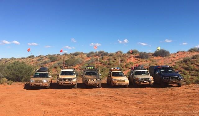
In the weeks leading up to the trip the area through Tibbuburra , Camerons corner, Innamincka to Birdsville was flooded again. Nevertheless, the trip across the Simpson was happening. The planned route was to meet in Mildura, head to Broken Hill, then head north to Tibuburra, then head up via all the corners to Birdsville for n east to west crossing of the Simpson. Then down the Oodnadatta Track and enjoy a couple of days exploring the Flinders Ranges before heading to the historic town of Burra, then home. A WhatsApp group was set up for the trip, and this has proved to be a really useful tool for group chatter and information. There was a plan B and if necessary, a plan C. What we didn’t know was that there were going to be a few more plans!!
Monday 23 May: We met up at the Buronga Caravan Park on the NSW side of the Murray just out of Mildura.
Tuesday 24 May: Everyone was up early to have breakfast and pack. The trip leader had not refueled the night before, so headed back into Mildura to get diesel. There was a very long queue at the servo. When he got back to Buronga everyone else had left camp and were waiting on the side road for us. The trip leader gets the first fine for the trip! We headed up the Silver City highway to Wentworth when it was suggested to go to the confluence of the Murray and Darling rivers. “It’s just down here,” and got everyone lost as we did a scenic tour of Wentworth. Second fine for the trip! After a photo stop, we were on our way again. After various photo stops and lunch, the convoy arrived in Broken Hill. 2 members were already in the campground, and another 2 members arrived shortly after. Whilst setting up camp, another 2 members arrived; however, they were staying in a hotel. Definitely another fine. A meeting was held, and it was agreed, due to the flooding, not to head to Tibooburra the next day, but instead head to Merna Mora Station in South Australia and hopefully up the Birdsville track. People then headed off to explore Broken Hill. That evening, we were all having dinner at the Musicians Club. One member said she knew the way and would lead. The five-minute drive turned into a half-hour trip. They got lost and blamed their GPS! Another fine.
Wednesday 25 May: We were all up early for the trip along the Barrier Highway to South Australia. There were stops along the way at the old settlements of Olary and Manna Hill. Then the rain started. At the quarantine checkpoint, all the cars were searched for fruit and vegetables. One couple was sprung with contraband, a tomato and a capsicum. From there, we all headed into Peterborough for lunch and fuel. From here we sped up to get to Merna Mora to set up camp and watch the sun setting on the Flinders Ranges opposite. One couple had left their caravan at Merna Mora for the trip home. So, they slept in their van on the other side of the dried riverbed.
Thursday 26 May: It was agreed we would stay another night and do one of the 4-wheel drive tracks on Merna Mora that traverses the ramparts of Wilpena Pound. The Bunbinyunna track has steep climbs and descents. The trip leaders for the day forgot to zero the trip meter for the track notes, hmmm! Another fine. There were many photo stops and the steep climbs, whilst challenging, no one got stuck. At the top of one peak, Paul rang Birdsville for an update and was advised that Birdsville could not be accessed from the Birdsville track as the flood waters were still rising. It was suggested that we should do a west-to-east crossing of the Simpson to allow the flooding to recede before we got there. Now for plan C. It was agreed this was a sensible approach, and we would stay another night and do the trip in reverse.
Friday 27 May: We headed up the R.M. Williams way to Brachina Gorge. Along the way, we stopped at some old Ghan rail ruins. The Flinders and Elder Ranges made a very scenic background. We then headed off the main road and aired down. Brachina Gorge is an amazing geological feature where the land has been forced upwards. From here, we headed up to Aroona and the Heysen Range for lunch and to explore. We returned to camp via the Bunnyroo Road and enjoyed the rugged and spectacular views of the Flinders Ranges.
Saturday 28 May: Everyone was packed early for the trip north up to Farina Station. There was a short stop at Parachilna and then on to Beltana township situated on the Beltana Station. We stopped for lunch and explored the town and read the sad and tragic stories recorded on the headstones in the cemetery. The convoy stopped at Leigh Creek for fuel. We arrived at the historic township of Farina and stopped at the underground bakery to buy fruit loaves, cakes, pies, etc. The underground bakery is open for 8 weeks a year and is staffed by volunteers from the Farina Restoration Society. We set up camp around a large picnic table whilst others went and explored the historic ruins of Farina. After watching the sun go down from the lookout and ANZAC memorial, we settled into dinner.
Sunday 29 May: A chilly start was the sign of the weather deteriorating. Everyone was packed and at the bakery to be first in when the doors opened at 8.00 am. At Marree, we stopped for morning tea. A last-minute check with Birdsville confirmed that we were heading up the Oodnadatta Track to William Creek. We stopped to look at the various sculptures and artworks at Plane Henge. At this point, the weather turned for the worse with torrential rain. The convoy stopped at Curdimurka Rail Siding, which has one of the many water stills that are along the old Ghan route, and then at Coward Springs for lunch. The Oodnadatta Track was now like a skating rink; the vehicles were slipping and sliding. At Strangways, an old telegraph station, we stopped for afternoon tea and a look. We rearranged the convoy order as the Subaru was without traction control, was struggling to stay on the track, and moved up behind the trip leader. At one point, the FJ nearly did a 180-degree turn. We also stopped at Mound Springs, which are natural hot water springs in mounds. As we approached William Creek, we noted that there was no oncoming traffic. At the top of the hill, just out of William Creek, a prime mover and a semi-trailer were left abandoned in the middle of the muddy track. We arrived at the William Creek Hotel, and they were surprised we had got through as the track had been closed sometime after we left Marree! The campground was being hammered by a strong wind that made putting up the tents a challenge. We had a lovely meal at the pub, which is a quintessential outback pub. After settling into bed for the night, we were awoken at around 1.00 am when one of the tents collapsed due to bent and broken poles. It was soon realised the tent could not be re-erected, and they retreated to their car for the night. Paul’s tent also had a fitting fail, and makeshift repairs were done.
Monday 30 May: Woke up to gale force winds, and the Oodnadatta Track north and south of William Creek was closed. It was an uneventful day. Tents were relocated one inside an outdoor kitchen, the other next to a shed. Without a tent, one couple made the sad decision to abandon the trip and take refuge in a cabin.
Tuesday 31 May: Only the track north to Oodnadatta was open to 4WDs and no towing. It was a sunny day, and we made good progress. You could see why the track had been closed and was not open for towing. At the old Peak Telegraph Station, we had lunch and explored the ruins as well as the old copper mine.
Wednesday 1 June: Just out of Oodnadatta we turned off the Oodnadatta Track and headed through Mt Sarah Station to Hamilton and turned on to the Pedirka Track, which is a public access route that had been closed for many years. It rained on and off, making the track very muddy. We stopped at Pedirka Siding and then Dalhousie ruins for lunch. The rain set in on the road to Mt Dare, making it very slippery. One member was sliding all over the road. It was quickly established he was in 2WD, problem solved. Another member reported a burning smell; however, it turned out to be an odour from a native plant. Mt Dare was a mud bath. Tents were pitched on the muddy ground, and refuge was taken in the hotel. The Pedirka Crossing was now closed, and so was the road out of Mt Dare to the Simpson. That night, the floor of one tent was flooded, so they slept in their car.
Thursday 2 June: We all had breakfast in the pub and debated heading off. It was decided we would have to stay another night at Mt Dare in the mud.
Friday 3 June: After breakfast, we were Simpson Desert-bound! The road out of Mt Dare was wet, muddy, and slippery. At Dalhousie Springs, it was sunny, and we stopped for lunch, and some took a dip in the hot spring. Slowly, the terrain changed from mud pans to sand and sand hills. We stopped at Red Mulga Creek, which was quite picturesque; however, despite the rain, it was relatively dry. Before we got to Purnie Bore, where we would camp for the night, we passed a group of walkers spread out over some distance on their way to Birdsville. That’s some walk.
Saturday 4 June: We set off from Purnie Bore into the desert along the French Line. The sand hills gradually got bigger, travelling from west to east. We stopped for lunch in a swale and picked up rubbish left by other travelers. Pushing on, we came across a bit of outback humour, a Tesla EV charging station, yeah right!! Everyone was enjoying the sand, and as we progressed east, the sand hills got steeper and bigger. A young couple came along the French Line from the east and set up camp next to ours, and kept to themselves. Later on, they provided a track condition update to Birdsville. The news was not good. The salt pan west of Poeppels Corner was flooded and impassable. You could travel some distance to get around it, however, there was no way out of Birdsville, as the surrounding flood waters were still rising. After some discussion on the situation, it was concluded that another plan change was required. Turning back was the only option, and doing a loop through the desert to either Purnie Bore or Dalhousie.
Sunday 5 June: Up early and advised everyone of the change of plan to plan number whatever! Yoga breathing exercises were conducted for the group. We headed west back along the French Line. It was quickly noted that sand hills that seemed easy yesterday were now difficult when climbing the eastern face. The day was quite challenging, and we called it a day just after 4.00 pm, setting up camp in a swale. It was also noted that travelling with the sun behind the desert colours was somewhat remarkable and different. We progressed along the French Line to Colsons Track, turning south to run parallel with the dunes. The vista was totally different, and the drive was relaxing with lots of tumbleweeds. At Linnies Corner, the intersection with the WAA Line, we stopped for morning tea, and with many climbing the surrounding dunes. The WAA Line, after a short distance, joined the Rig Road. The lunch stop was at the abandoned Mokari oil well and airstrip. Most of the group climbed a very high dune that provided a commanding view of the air strip and the desert. The convoy then headed northeast along the Rig Road for 13 km, where it rejoined the French Line. From here, it was agreed we would try and make it to Dalhousie rather than staying at Purnie Bore. Progressively, the sand hills became smaller and easier to traverse. Arriving at Purnie Bore, the sand flags were removed. The walking group we had passed a couple of days earlier had set up a rather large base camp at Purnie Bore. We were glad to keep going. As we headed west, the terrain changed from sand hills to mud pans that were still very wet. As dusk was approaching, the convoy sped up to get to Dalhousie whilst there was still light. On arriving at Dalhousie, the campground was rather crowded. The convoy drove around until we located a place where we could all camp together. That evening, the mozzies struck with vengeance. One member had over 100 bites and was not happy. Much discussion was had after dinner concerning the next day’s plans, when the group would split up.
Monday 6 June: On getting up this morning, a number left the trip and were heading to Mt Dare and then on to Alice Springs. The rest of the group headed out along the Pedirka Track, which was very wet. As we approached Oodnadatta, a very large, angry dingo voiced its disapproval at the vehicles. After stopping at Oodnadatta for lunch and refueling, another member headed off on their own to Coober Pedy via the Painted Desert. The convoy, now very small with five members, headed down a very busy Oodnadatta track to William Creek. Along the track we encountered a very large snake crossing the track. Just glad we were driving! South of Oodnadatta, the track was in poor condition with numerous small water crossings and lots of insanely fast oncoming traffic firing many rocks at us like missiles heading up to Finke for the races. Following arrival at William Creek, a couple of the group had to contend with cold showers. We all went to the pub for dinner and chatted with other travelers before calling it a night.
Tuesday 7 June: After breakfast, we headed off. The track was in poor condition following the earlier rain, with many washouts full of water. Members had their windscreen and spotlight cover broken by stones flicked up by the oncoming traffic. We stopped at Beresford Siding, which was an interesting ruin comprising old buildings, water still, and a lake. Just after the Curdimurka ruins, we stopped at the viewpoint for Lake Eyre South. We pressed on and had lunch at Marree before heading to Farina. Naturally, we headed straight to the bakery before setting up camp. That night we watched the sun go down, followed by dinner, and then off to bed.
Wednesday 8 June: As you do in Farina, we headed to the bakery before making our way down to the Flinders Ranges, where we met up with members who had left the trip at Merna Mora for morning tea at Parachilna. We then continued south to Craddock for lunch. We arrived at Burra after a long drive, some members set up camp at the Bon Accord hotel, whilst the others went in search of a motel. Later, we all met up at the Bon Accord for dinner, where the trip was officially declared to be over.
Wombat State Park – April/May
This was a weekend away staying at Lerderderg Campground. The first night the rain hammered down and the wind was quite strong. By the morning the rain had stopped. We headed out on Diggers Track. The track descended sharply over Sardine Creek, and we started the steep climb on the northern side. The track was rocky and had been made slippery by the overnight rain. We decided that it was not worth pushing ahead and we went in search for something a little easier.
Ambler Lane Track which was further west on the other side of the Lerderderg River which was crossed at O’Brien’s Crossing. We walked down to the river and to Point Tunnel, where the Lerderderg River was diverted through a fissure in the rock by miners to expose a large section of the riverbed for gold mining.
Back to the vehicles and the rest of the traverse along Amblers Lane Track. This occupied the group until lunch. There were many stops to inspect the numerous brown puddles that had probably expanded and deepened during the night. We ended up in Trentham for lunch.
After lunch we headed down Ottie Track. This had only just been opened after tree damage closed it. It was very slippery and one vehicle had to be recovered. Back at camp a good night was had in front of a fire.
See newsletter #40, May 2022 for the full trip report
Wangaratta
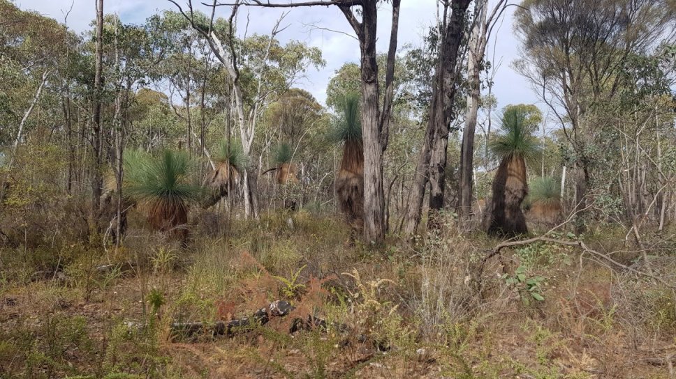
We did an Easter trip up to Wangaratta and the surrounding area. We stayed at Wenhams Campground in Ovens-Warby National Park. The first day we had a drive around the park. There are some amazing grass trees along Adams Road. We went to Pine Gully Picnic area and did the walk to the lookout. There was no water in the water fall with it being only the start of autumn. However the walk was nice and the view was lovely. We considered the Pangarang Lookout walk, but we didn’t think we had enough energy to do both walks.
Instead we went to Warby Tower lookout. The tower is no longer there, just the remnants of where it was, but the views are good. We had lunch at Spring Creek Picnic area.
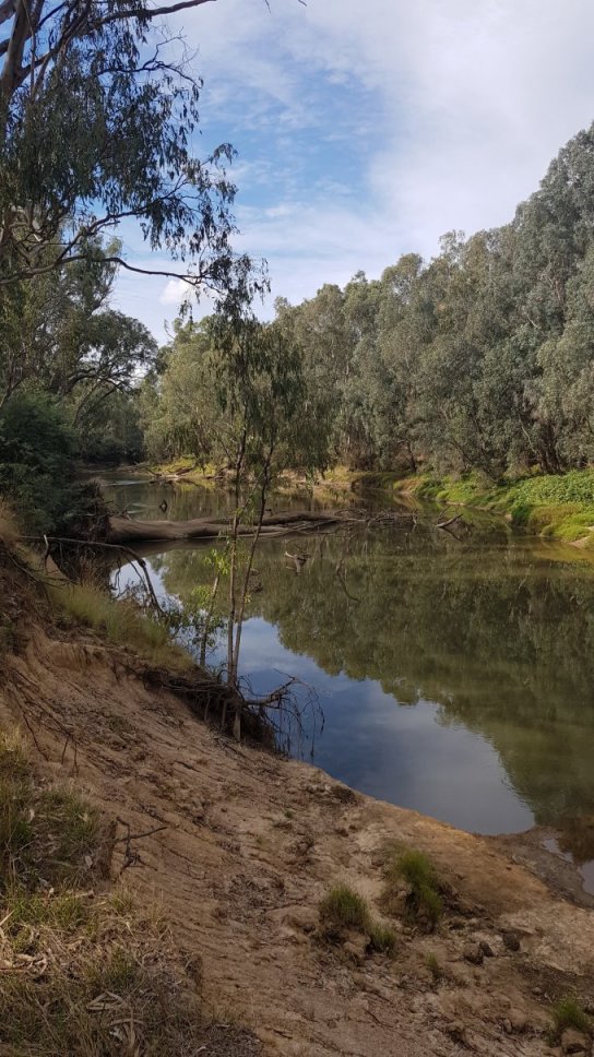
Then we went to Killawarra to get the the Ovens River. We left the highway, and crossed the bridge over a creek and onto Hills Track. We had a nice drive along the river via Wilsons Track and Ovens Track. The tracks are easy with the occasional pot hole and rut to avoid. There are many campgrounds along the river. All but one had people in them, but given that it was Easter, they were not especially packed. The river drive is very scenic.
On the way back to camp we stopped and did Ryan’s Lookout. This is a short walk up to a tower where there are great views. Then it was back to camp for dinner and a chat around the fire.
The next day we went into Benalla and had morning tea at the art gallery. This is a very beautiful spot overlooking the lake. Then we followed this up with a bit of a walk around the town to admire the street art.
We went off to Winton Wetlands and had a late lunch at the outlet channel of Lake Mokoan. We had a drive through the wetlands and stopped on top of Green Hills for a cuppa. Snakes were a plenty. One of our party saw a brown snake, while another person saw a red bellied black snake. Neither snake hung around for a photo opportunity and were gone like a rocket. We went past the Art water tank and went down Nelson Road to the parks exit. Then back to camp for dinner and another fire.
The next day we headed out past Wangaratta to Eldorado to have a look at the dredge.
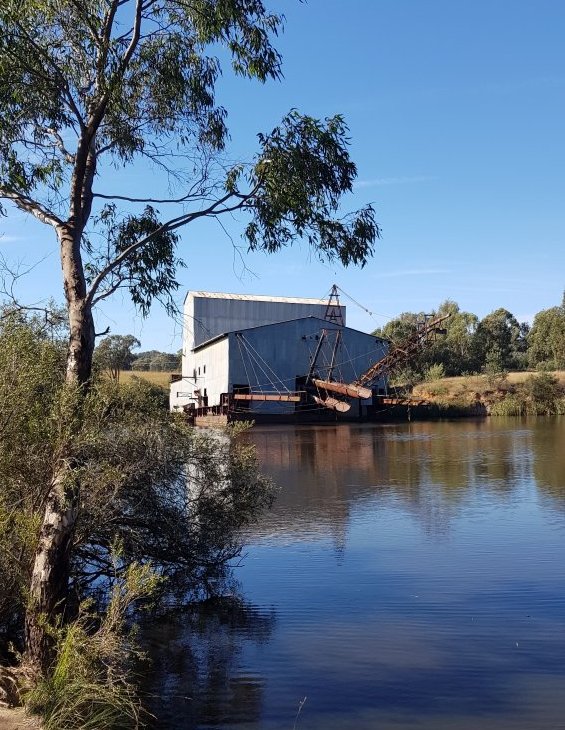
The Cocks Eldorado Dredge is moored in a little river siding. We had a looked around the dredge, which was 64 metres long, 20 metres wide at the stern and 50 metres wide at the bow. The whole dredge weighed 1880 tonnes. We did a walk around the lake where the dredge is. It’s definitely work a look and it is quite informative.
We went into Eldorado itself and had coffee at the general store. Went and brought a few pieces of pottery at the pottery place. Then we had lunch at the suspension bridge.
We then picked up the silo art trail and had a look at the art work there. We have previously run a trip here before, see “Painted Silos of North East Victoria 2021”
We had afternoon tea at Tungamah Weir. This is a lovely camping ground, which was busy, but not packed. We followed the Devenish road back to Goorambat where the Uniting Church was open so we could see the amazing art work of St Sophia, as well as the silo art work just up the road.
After this it was back to camp for dinner and another fire.
See newsletter #44, September 2022 for the full trip report
Pyrenees – March
We have visited Avoca and Moonambel quite a few times. The area has some very good wineries, scenic spots and great 4WD tracks. Many of the track have had little or no maintenance over the last 8 or so years. This has made the difficult tracks extreme and the extreme tracks – well, still extreme.
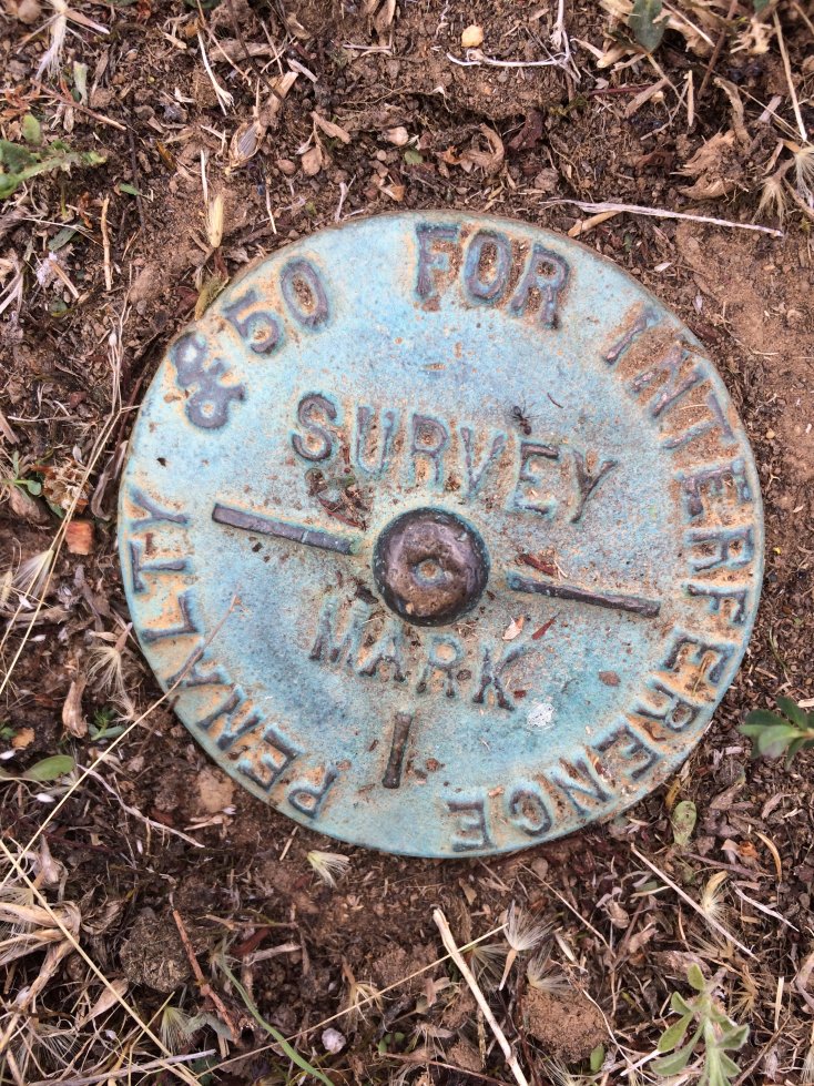
So we were a little circumspect where we went. We did Landsbrough Ridge Track. It has a short section that was a few washouts. One of the vehicles with us got stuck with his tow bar on a rock. Because of the steep slope and the angle of his vehicle, it was not a simple recovery and it took about an hour to get him going again. At the top we found a survey marker with an interesting nomination for the fine. We returned back to camp along Blue Mountain Track and Cactus Track. Both of these tracks were in very good condition.
The Next day we went north into Kara Kara National Park. The tracks from Moonambel campground to the park were a bit of a mixed bag. A little more rutted than I remember from last time, but in general not too bad. We headed along Centre Road and turned off on Blue Gum Track. A large section of this track looked like a dry river bed as it was mostly exposed rock. It was firm rock, so easy going, but a unusual sight to see.
We followed this to Teddington Track, past the hut to to the Teddington Reservoir. We had lunch here and a walk around the lower reservoir. After lunch we headed to the New England Range fire tower. It is a great view.
On the return back to camp, Once out of the National Park, we returned to camp via Long Gully Track and Bridle Track. There has been a lot of work done on the two hairpin turns along Long Gully. The bends have a spot where larger vehicle can back into to do a three point turn, and the approach is a lot better.
The next day we did a few tracks just north of the campground. Some sections proved a little too much for my vehicle, and other were certainly a challenge.
See newsletter #41, May 2022 for the full trip report
Castlemaine – March
We stayed at Leanganook Campground at Mt Alexander. We took a drive up to the cairn at the top of the mountain, then to Dog Rocks lookout. We dropped into to one of the old quarries for a quick look. Then we went to the Oaks for morning tea and lunch. We took a drive to the old Welsh Village and had a walk around there.
The next day we went to the Garfield water wheel and then the Botanical Gardens for lunch. In the afternoon we drove to the top of The Monk and did a few other 4WD tracks.
See newsletter #39, April 2022 for the full trip report
Cheese Making – February
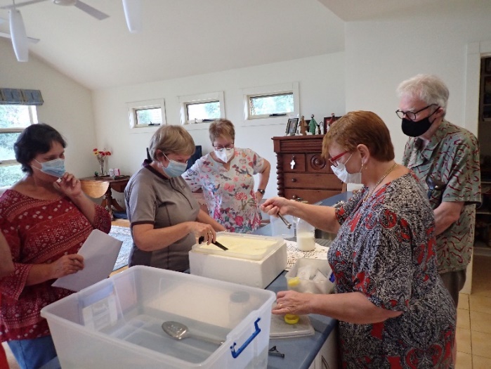
After a bit of a delay due to COVID, the cheese making day finally went ahead. Fetta was the first cheese for the day. We heated the milk to the correct temperature then the starter, calcium and rennet were added and the container was covered with towels. 90 minutes later we cut the curd and left it for another 30 minutes. The curds were gently turned to break them up before scooped into the hoops to drain.
Next it was Blue cheese. This would need to be finished off at home and it would take about 3 months for the mold to grow.
See newsletter #38, March 2022 for the full trip report
Yarra State Forest – Australia Day
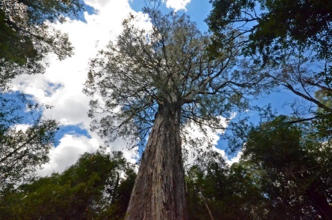
The trip started in Warburton. We started along Riverside Drive, a short picturesque drive along the Yarra River. We followed Big Pat’s Creek Road before turning left onto Smyth Creek Road to Stirling Gap. We continued driving through areas of large tree ferns and everyone just enjoying being out in the bush. We soon arrived at the Ada Tree car park. Some did the 3km walk to the tree.
After lunch we took the New Turkey Spur Road to come out onto the Yarra Junction Noojee Road and turned right to make our way into Powelltown.
We stopped in Powelltown for ice creams. We then turned left onto the Learmouth Creek Road and made our way to the Seven Acre Rock. This was a pleasant walk through the bush and then a bit of scrambling over rocks to get to the lookout.
The rain came, and e got as bit wet walking back tot he car. We travelled along the Bunyip Road and onto the East Beenak Road. The bush around us took on a new kind of beauty with the rain and the steam rising off the roads. By the time we entered Kurth Kiln Regional Park the rain and stopped.
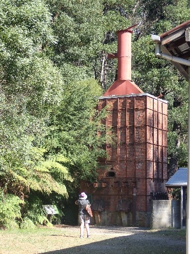
We arrived at Kurth Kiln for afternoon tea. During the 2nd World War, due to petrol shortages, the kiln was built to burn timber for charcoal which was then used to produce gas to run vehicles. There was also housing built for the timber workers and those working on the kiln.
See newsletter #37, February 2022 for the full trip report
Canunda National Park – Australia Day
This was a fixed camp staying at Oil Rig Square campground in Canunda National Park. The campground is accessible by a 2WD road and is suitable for tents, campers and medium size caravans. It is situated in the middle of the park and close to Millicent, maybe about 15km.
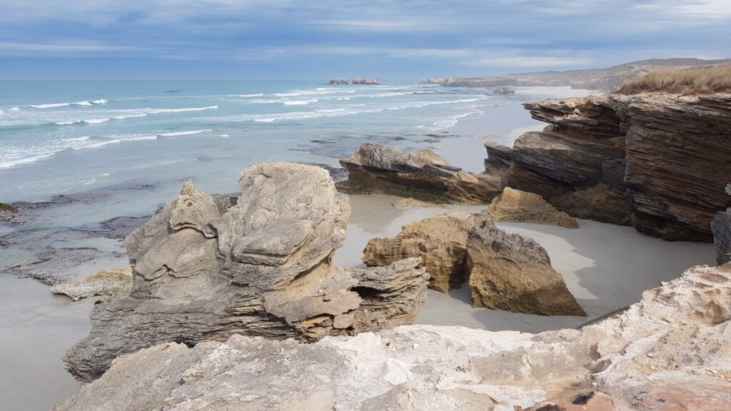
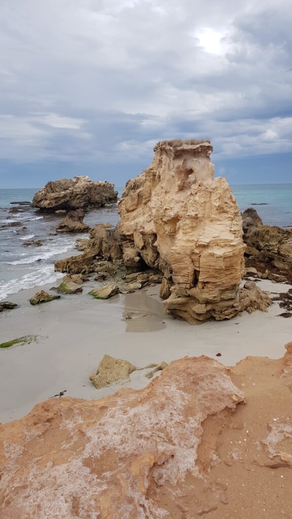
Wednesday: we headed down to Geltwood beach and headed north along the beach. We went inland at the first track off the beach. The inland track is a bit of mixed bag, with mostly hard packed sand, some rocky sections and a few dunes with some soft sand.
The coastal views here are spectacular, with some of the best scenery available in Australia. There are rock pools and swimming holes, caves cliffs and island rocks just off the coast. There are a few tracks that go out to McIntyre Beach, and they are well worth taking.
We had lunch at Southend, where it poured with rain for about 15 minutes. We stood under a shelter and ate. We then headed back to camp via Khyber Pass Track. It was a pleasant drive, but it was not the most direct route route back to camp and left a bit of a loop along a couple of 2WD roads.
Thursday: today we were going to look at the southern end of the park. Our stop was to Coola outstation. There is not much there, but the place had an interesting history. There were some walking tracks down to the Lake Bonney (and possibly a 4WD track also), but we did not have a lot of time to spend there.
The land here was very stark and windswept. It was reminiscent of photos of Mars surface. We took the track to Whale Rock Soak, but at the end of the track, we could not really work out what we were looking at. We headed back to the main track and then up to the wind farm lookout over Lake Bonney.
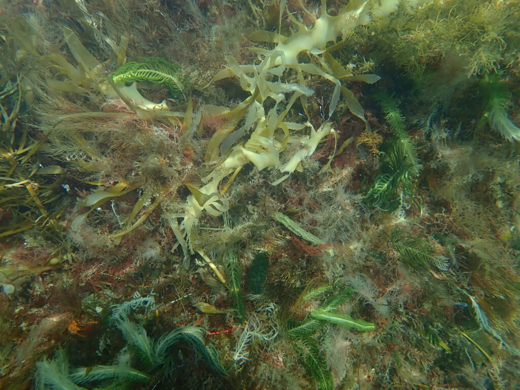
At No. 2 Rocks there is a gorgeous lagoon to swim in. It is well worth putting in a mask and snorkel as there is a patch of sea weed that is very beautiful. It has different types with different colours.
We ended up at the Cape Banks Lighthouse. We aired up and took the highway back to camp.
Friday: today we were going to do a few of the more touristy things. We drove down the wind farm scenic drive on the way to Tantaloona cave (south of Millicent). The cave is not very large, but it is full of interesting and beautiful things to look at. There are stalactites, stalagmites, columns and shawls. It was found in 1930 and it is wheel chair accessible.
Morning tea was at Beachport where some people had a walk along the jetty, while other brought fish and lobster.. Then we headed to Robe, stopping at Woakwine cutting. This is an impressive cutting to drain a swamp into a neighbouring lake to make the land farmable. It was done in the late 1950s using a D7 tractor. The cutting is 1km long and 28m at its deepest point.
We then went for a short drive in Little Dip Conservation Park.
See newsletter #37, February 2022 for the full trip report