Why Visit
Arkaroola appeals to adventurers, nature lovers, photographers, and anyone seeking a remote, authentic outback experience. Its mix of geology, wildlife, and stargazing makes it one of Australia’s most remarkable wilderness getaways.
Getting There
- Arkaroola is accessible via 4WD or well-prepared 2WD vehicles from the towns of Leigh Creek or Copley.
- The journey itself is part of the experience, taking travellers through classic Flinders Ranges country.
Accommodation and Facilities
- Arkaroola Village offers a range of options, from motel-style rooms and self-contained cottages to campsites.
- Facilities include a restaurant, bar, swimming pool, and visitor information centre.
A Brief History
Arkaroola is a privately owned wilderness sanctuary located in the Northern Flinders Ranges, about 600 km north of Adelaide. It’s known for its rugged mountain landscapes, unique geology, and importance in conservation and astronomy.
Early History
- Indigenous heritage: The area is part of the traditional lands of the Adnyamathanha people, who have lived in the Flinders Ranges for tens of thousands of years. “Arkaroola” is believed to come from an Adnyamathanha word referring to “place of water” or “spring.”
- The region contains many significant Aboriginal sites, including rock engravings and stories tied to Dreaming tracks.
European Exploration and Settlement
- Mid-1800s: European explorers such as Edward Eyre and John McDouall Stuart passed through the Flinders Ranges.
- Pastoral leases were later established, but the harsh environment made sheep grazing difficult. Repeated droughts led many settlers to abandon the land.
Mining Era
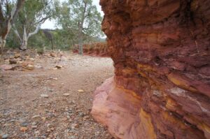
- From the late 1800s to mid-1900s, Arkaroola saw sporadic mining for minerals like uranium, copper, and gold. The region became notable for its complex geology, which attracted scientists and prospectors alike.
The Sprigg Family and Conservation
- In 1968, Reg Sprigg, a renowned geologist, environmentalist, and founder of the South Australian branch of the Nature Conservation Society, purchased the property.
- He and his family established Arkaroola Wilderness Sanctuary, focusing on ecotourism, scientific research, and environmental preservation—a pioneering idea at the time.
Modern Era
- In 2011, after years of controversy over proposed uranium exploration in the area, the South Australian Government permanently banned mining at Arkaroola, recognising its ecological and geological significance.
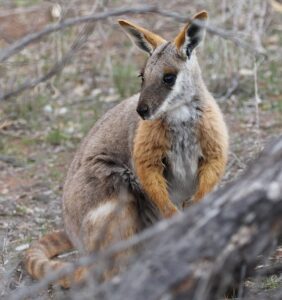
- Today, Arkaroola is famous for its astronomical observatories, 4WD eco-tours, rare wildlife (such as the yellow-footed rock-wallaby), and world-class geology, including evidence of ancient glaciations.
Natural Highlights
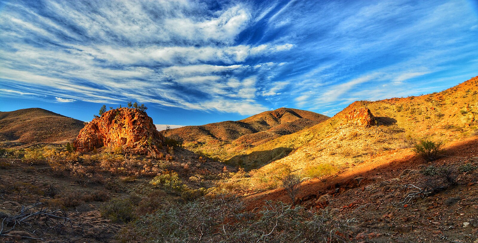
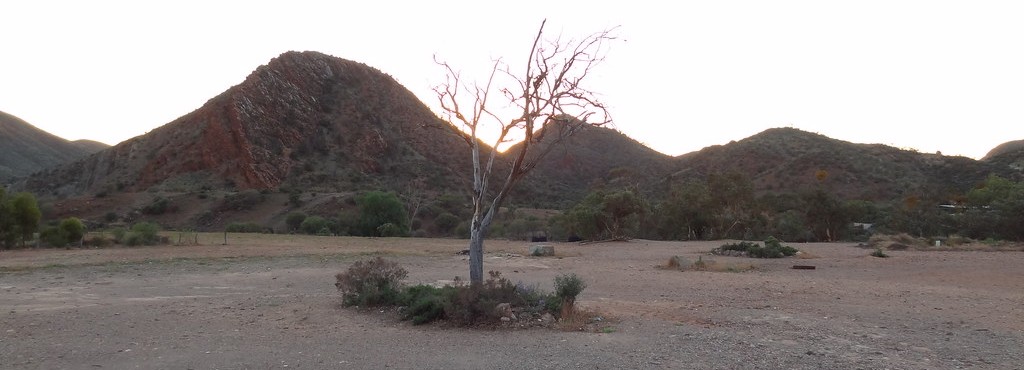
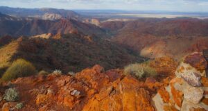
- Spectacular Scenery: Arkaroola’s terrain features jagged mountain peaks, deep gorges, and ancient granite and quartzite formations—some over 1.6 billion years old.
- Ridgetop Tour: The signature experience is the Ridgetop 4WD Tour, which takes visitors across steep ridges to the famous Sillers Lookout, offering panoramic views over the desert ranges.
- Walking Trails: Numerous hiking routes explore gorges, creeks, and lookouts, with options for all fitness levels.
- Acacia Ridge Walk (great views of the ranges)
- Echo Camp Backtrack (remote and rugged)
- Spriggina Trail (geological highlights)
Waterholes and Gorges
- Explore sites like Bollabollana Springs, Bararranna Gorge, and Stubbs Waterhole.
- These spots often hold permanent water and attract wildlife — perfect for a peaceful picnic.
Wildlife and Environment
- Arkaroola is home to many rare and protected species, including the yellow-footed rock-wallaby, wedge-tailed eagles, and unique arid-zone flora.
- Early morning and dusk are the best times for wildlife viewing.
- Birdwatchers will enjoy spotting over 160 recorded species.
- The sanctuary is a model for sustainable tourism, balancing visitor access with conservation and research.
Astronomy and Science
- With its clear, dry air and minimal light pollution, Arkaroola is a world-renowned astronomy destination.
- Visitors can use powerful telescopes at the Arkaroola Observatory or join guided night-sky tours.
4WD Tracks
- Ridge Top Track (Guided Only)
- The most famous and spectacular drive in Arkaroola.
- Only accessible on a guided tour due to its difficulty and steep terrain.
- Climbs through narrow ridges, dramatic valleys, and exposed mountain tops to the Sillers Lookout, where views stretch across the Northern Flinders Ranges and towards the Lake Frome basin.
- Showcases unique geology, including 1.6-billion-year-old rocks and fossils.
- Echo Camp Backtrack (Self-Drive)
- A popular self-guided 4WD route, suitable for well-prepared drivers.
- Winds through rugged hills and dry creek beds, passing Echo Camp, Stubbs Waterhole, and Spriggina Ridge, where fossil imprints of early life have been found.
- Offers stunning views of the Mawson Valley and opportunities to spot wildlife like yellow-footed rock wallabies.
- Mt Jacob Backtrack
- A medium to challenging 4WD track that ascends steep ridges and rocky paths.
- Leads to Mt Jacob Lookout, providing panoramic views of the Gammon Ranges and Freeling Heights.
- Known for its sense of isolation and excellent photo opportunities, especially at sunrise or sunset.
- Stubbs Waterhole Track
- Easier 4WD track suitable for those looking for a shorter adventure.
- Travels along scenic creek beds and leads to Stubbs Waterhole, a tranquil spot often used for picnics or wildlife watching.
- Mawson Valley Track
- Takes you deep into Arkaroola’s remote valleys and ridgelines.
- Excellent for geology enthusiasts — this area was studied by Sir Douglas Mawson, Australia’s famous geologist and explorer.
- A great way to experience the raw, untouched side of the Flinders Ranges.
Useful Tips for Driving in Arkaroola
- Check in at the Arkaroola Village Office before heading out — staff provide maps, weather updates, and track conditions. Some tracks may close after rain for safety or conservation.
- Plan your routes in advance and allow plenty of time; distances can be deceptive due to slow, rocky terrain.
- Always let someone know your route and expected return time, even if you’re staying within the sanctuary area.
- A high-clearance 4WD is essential for most of Arkaroola’s backtracks (e.g. Echo Camp, Mt Jacob).
- Ensure your vehicle is well-maintained, with good tires, working low-range gears, and a full tank of fuel (fuel is available at Arkaroola Village).
- Carry essential recovery gear:
- Tyre deflator & compressor
- Snatch strap & shackles
- Shovel
- Traction boards (optional but useful)
- Lower tyre pressures slightly on rough, rocky roads (around 26–30 psi), but reinflate before returning to sealed roads.
- Bring plenty of water — at least 5 litres per person per day — and extra food in case you’re delayed.
- Carry a first aid kit, sunscreen, a hat, and insect repellent.
- Mobile reception is limited; bring a UHF radio (Arkaroola recommends Channel 10 or as advised by staff) or a satellite phone if going remote.
- Avoid driving after dark — wildlife such as kangaroos, emus, and wallabies are very active at dusk.
- Drive slowly and steadily — rocky sections, dry creek crossings, and steep climbs require control rather than speed.
- Engage 4WD early on steep or loose terrain to maintain traction.
- Descend steep hills in low range, first gear, letting the engine braking do the work.
- Be cautious of washouts, sharp rocks, and sudden drop-offs — these are common, especially after rain.
- Avoid disturbing wildlife and keep to marked tracks to protect fragile desert ecosystems.
- Take time to stop at lookouts like Sillers Lookout (on guided Ridge Top Tour) or Mt Jacob Lookout for panoramic photos of the Flinders Ranges.
- Early morning or late afternoon are the best times for photography and wildlife spotting.
- Respect cultural and environmental heritage — some areas have Aboriginal significance or rare geological formations.
- Summer temperatures can exceed 40°C, so travel is best from April to October.
- Tracks may close temporarily after heavy rain or during fire danger periods — always check before heading out.
- Carry a paper map or download offline GPS maps — don’t rely solely on mobile navigation.
Useful Links
- The Arkaroola Wilderness Sanctuary: https://www.arkaroola.com.au/
- Arkaroola, SA: https://www.aussietowns.com.au/town/arkaroola-sa
- Arkaroola Wilderness Sanctuary: https://southaustralia.com/products/flinders-ranges-and-outback/attraction/arkaroola-wilderness-sanctuary
- Arkaroola Wilderness Sanctuary: https://www.ritas-outback-guide.com/arkaroola.html
- The Arkaroola 4WD Ridgetop Tour: https://www.arkaroola.com.au/ridgetop-tour
- Arkaroola Wilderness Sanctuary Accommodation: https://flindersandoutback.com.au/listings/accommodation/arkaroola-wilderness-sanctuary-accommodation/
- The Flora and Fauna of Arkaroola Wilderness Sanctuary: https://www.arkaroola.com.au/wildlife
- Arkaroola: https://www.environment.sa.gov.au/our-places/arkaroola
- Self Drive 4WD Tracks: https://www.arkaroola.com.au/self-drive-4wd
- Arkaroola 4WD Loop: https://www.exploroz.com/treks/arkaroola-4wd-loop
- Arkaroola 4WD Tracks; beautiful, rugged and proper off road: https://www.4wdingaustralia.com/travel-south-australia/arkaroola-4wd-tracks/
- Arkaroola Ridgetop Track: South Australia: https://www.4x4australia.com.au/explore/sa/arkaroola-ridgetop-track-south-australia
- Echo Camp Back Track: https://thisadventurousage.com/tag/echo-camp-back-track/
- Things to do at Arkaroola – the ultimate travel guide: https://nigelandsueadventures.com/arkaroola/
- Arkaroola: Acacia Ridge Walk (6.5km): https://www.trailhiking.com.au/hikes/arkaroola-acacia-ridge-walk/?srsltid=AfmBOopGnPpAQxeCXfhdjiXhJcCjALzoXckVr1s0lRMwFOHmPP0qrZXL
- Observatory Tour: https://www.arkaroola.com.au/observatory-tour
- Astronomy Experiences: https://www.arkaroola.com.au/astronomy-tours
- Discover Arkaroola’s Ancient Landscapes: A Geologist’s Dream: https://www.arkaroola.com.au/discover-arkaroolas-ancient-landscapes-a-geologists-dream
- Geological Field Excursion Guides to Arkaroola: https://flinders-ranges.com/2023/01/18/geological-field-excursion-guides-to-arkaroola/
- Reg C Sprigg: https://www.arkaroola.com.au/reg-sprigg
- Reginald Claude (Reg) Sprigg (1919–1994): https://adb.anu.edu.au/biography/sprigg-reginald-claude-reg-19112
- Paralana (Radioactive) Hot Springs – Arkaroola, SA, Australia: https://www.tophotsprings.com/paralana-hot-springs-australia/
- The stars come out to shine in Arkaroola: https://theoutbackloop.com.au/stories/the-stars-come-out-to-shine-in-arkaroola/