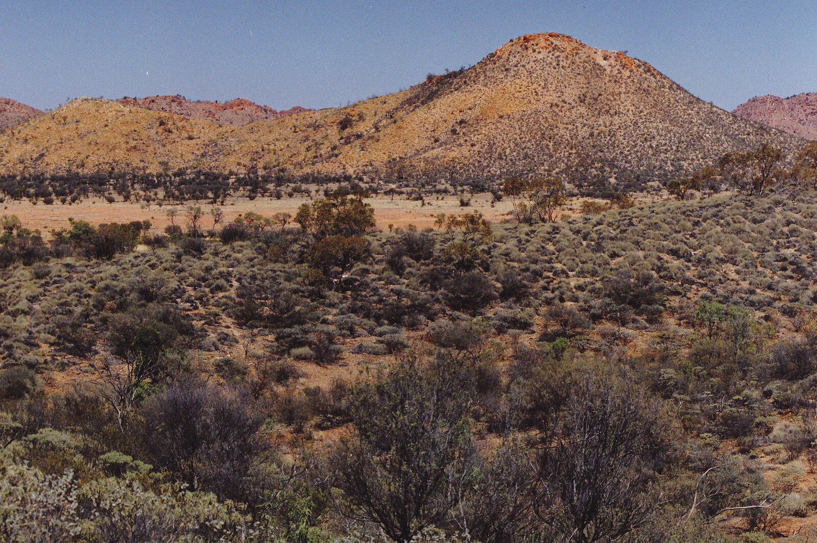
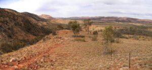
The MacDonnell Ranges, located in the heart of Australia’s Northern Territory, stretch for hundreds of kilometres both east and west of Alice Springs, forming one of the country’s most striking and ancient landscapes. These rugged mountain ranges are around 300–400 million years old, shaped by dramatic geological forces that created deep gorges, chasms, and waterholes.
The MacDonnell Ranges are an ancient mountain range that stretch for more than 600 kilometres across Central Australia, west and east of Alice Springs. They were formed over 300–350 million years ago during a major geological event known as the Alice Springs Orogeny, when massive tectonic forces caused the Earth’s crust to fold and uplift, creating the rugged ridges and gorges that define the landscape today.
For tens of thousands of years, the ranges have been home to the Arrernte people, who hold deep spiritual and cultural connections to the land. Many significant Dreaming stories, rock art sites, and sacred places — such as Simpsons Gap, Standley Chasm, and Ormiston Gorge — are found throughout the ranges and continue to play an important role in Aboriginal culture and law.
European exploration began in the 1860s, when surveyor John McDouall Stuart crossed the region on his expeditions, and the range was later named after Sir Richard MacDonnell, the Governor of South Australia at the time. With the arrival of settlers and the construction of the Overland Telegraph Line in the 1870s, the area became more accessible, eventually leading to the establishment of Alice Springs as a key outback town.
Today, the MacDonnell Ranges are celebrated for their striking red rock formations, ancient geology, and deep cultural significance — a place where the natural and spiritual history of Central Australia intertwine.
The MacDonnell Ranges vary in height along their length, but they include some of the highest mountains in the Northern Territory.
Highest Peaks in the MacDonnell Ranges
- Mt Zeil – 1,531 m
- The highest peak in the Northern Territory and the highest point in the MacDonnell Ranges.
Located in the West MacDonnell Ranges, west of Mt Sonder.
- The highest peak in the Northern Territory and the highest point in the MacDonnell Ranges.
- Mt Sonder – 1,380 m
- The famous Larapinta Trail finish point and one of the most photographed mountains in Central Australia.
Amazing sunrise views from the summit.
- The famous Larapinta Trail finish point and one of the most photographed mountains in Central Australia.
- Mt Giles – ~1,389 m
- A rugged, rarely climbed peak near Ormiston Gorge.
One of the most remote and dramatic mountains in the region.
- A rugged, rarely climbed peak near Ormiston Gorge.
General Range Height
Along most of their length, the MacDonnell Ranges rise to 600–900 m above sea level, with some ridge lines and peaks exceeding 1,000 m.
The ranges themselves stretch over 640 km across Central Australia, creating a long chain of ridges, gorges, and folded red quartzite mountains.
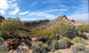
Natural Features and Attractions of the MacDonnell Ranges
West MacDonnell Ranges
- West MacDonnell Ranges (Tjoritja National Park)
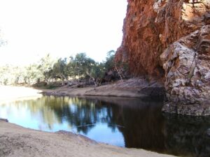
- The West MacDonnell Ranges stretch west of Alice Springs and are home to some of Central Australia’s most breath taking landscapes. Towering red cliffs, cool waterholes, and dramatic gorges make this area perfect for hiking, swimming, and photography.
- A Parks Pass is required to enter.
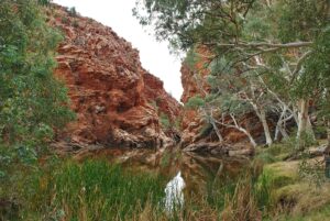
- Simpsons Gap
- A striking gorge with towering cliffs and a permanent waterhole — especially beautiful at sunrise and sunset when the rocks glow deep red. You might spot black-footed rock wallabies here.
- Standley Chasm (Angkerle Atwatye)
- A narrow, 80-metre-high chasm carved through the quartzite rock. It’s most spectacular around midday when sunlight beams directly into the chasm, illuminating the walls with a fiery orange glow.
- Ellery Creek Big Hole
- One of the region’s most popular swimming spots — a deep, cool waterhole surrounded by towering cliffs. It’s part of the long-distance Larapinta Trail and has a campground nearby.
- Serpentine Gorge and Serpentine Chalet Dam
- Quieter and less visited, these sites offer peaceful walks and birdwatching, with steep rock walls and shady waterholes.
- Ormiston Gorge
- A stunning gorge with a permanent waterhole, walking trails, and striking views of the surrounding ranges. It’s also an excellent spot to see rock wallabies and native birds.
- Redbank Gorge
- Located near Mount Sonder, this narrow gorge features deep pools of icy water and is perfect for adventurous swimmers. The nearby Mount Sonder Lookout offers spectacular sunrise views.
- Mount Sonder (Rwetyepme)
- One of the highest peaks in the Northern Territory. A challenging hike to the summit rewards you with panoramic views over the West MacDonnells and beyond.
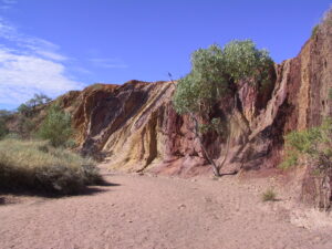
- Ochre Pits – A colourful quarry site traditionally used by the Arrernte people, where natural ochres in shades of red, yellow, and white were collected for ceremonies and artwork.
East MacDonnell Ranges
Less visited but equally beautiful, the East MacDonnells offer rich Aboriginal history, unique rock formations, and serene natural landscapes.
- Emily and Jessie Gaps Nature Park
- Two small gaps close to Alice Springs featuring ancient Aboriginal rock art depicting caterpillar Dreaming stories significant to the local Arrernte people.
- Corroboree Rock Conservation Reserve
- A striking dolomite rock formation and important ceremonial site for the Arrernte people, surrounded by desert oaks and scenic walking trails.
- Trephina Gorge Nature Park
- Known for its wide, sandy creek beds, towering quartzite cliffs, and clear walking tracks. The Trephina Gorge Rim Walk offers superb views across the ranges.
- N’Dhala Gorge Nature Park
- Home to over 6,000 ancient rock carvings (petroglyphs) and important sacred sites. Accessible by 4WD, it provides a fascinating glimpse into the region’s deep cultural history.
- Arltunga Historical Reserve
- Central Australia’s first European settlement and gold mining site from the late 1800s. The old stone buildings and mining relics tell the story of early European exploration and survival.

You will need a parks pass to visit these parks:
- Arltunga Historical Reserve
- Corroboree Rock Conservation Reserve
- Ellery Creek Big Hole
- N’Dhala Gorge Nature Park
- Redbank Gorge
- Ruby Gap Nature Park
- Owen Springs Reserve
- Simpsons Gap
- Tjoritja / West MacDonnell National Park
- Trephina Gorge National Park
Places to Stay in the West MacDonnell Ranges
- Discovery Resorts – Glen Helen
- This is the only full-service accommodation inside the park — motel-style rooms + a campground (powered and unpowered sites).
- It features a restaurant/bar, camp kitchen, swimming pool, fuel and supplies — a great base if you want convenience, comfort, and easy access to the surrounding gorges and trails.
- Closest major gorge: Glen Helen Gorge on the Finke River — perfect if you want a comfortable stay while exploring the outback landscapes.
- Note: “Please note, due to concerns with our water supply and associated facilities, Discovery Resorts – Glen Helen is temporarily closed. We apologise for any inconvenience caused.” 1It’s smart to check availability before making plans.
- Campgrounds within the National Park
- If you prefer camping under the stars and want to stay close to nature, the park has several official campgrounds. Be sure to book ahead online and bring your own water.
- Ormiston Gorge / Pound Campground
- Equipped with showers, toilets, gas barbecues — fairly comfortable by outback-camping standards.
- Great natural setting: the gorge has a waterhole and surrounding red-rock cliffs.
- Ellery Creek Big Hole Campground
- Popular campsite adjacent to one of the park’s most famous waterholes — ideal if you want a swim + camping in one.
- Facilities include toilets and basic camping amenities; caravans are allowed at this 2WD-accessible site.
- Redbank Gorge (Ridgetop or Woodland) Campground
- Basic facilities (toilet, fire-pit / picnic table) — not fancy, but situated in a dramatic gorge landscape.
- Access often requires more rugged driving (4WD recommended, depending on conditions) — good for those seeking solitude.
- More Remote / 4WD / Bush-style Sites
- Sites like Serpentine Gorge (via the old Serpentine Chalet), Birthday Waterhole, 4WD-only Finke River 2‑Mile Campground, and other bush camps offer a true “roughing it” experience for those fully prepared — ideal for self-sufficient campers and 4WD adventurers.
- Budget / Close-to-Town Alternatives
- If you’d rather not stay inside the park — or if full campsites / lodge rooms are booked — base yourself near the town of Alice Springs and drive into the ranges when ready. Nearby outside-town options like a boutique tent stay or can offer an easier fallback base.
- Example: Squeaky Windmill Boutique Tent B&B — just outside town and offers a comfy, eco-tent stay with a deck, basic facilities, and a relaxing outback vibe while still being easy to access before/after your park adventures.
Choosing the Right Stay for You
- Want comfort + convenience inside the ranges? → Glen Helen (if open) offers motel rooms, meals, and all-round facilities.
- Want to camp but with basic amenities (showers, toilets)? → Ormiston Gorge or Ellery Creek Big Hole are good bets for a nice balance.
- Seeking solitude, rugged outback feel, 4WD adventure? → Redbank Gorge or remote bush-style camps (Serpentine Gorge, Finke River 2 Mile, etc.) deliver the raw outback experience.
- Prefer flexibility + easy access to services (fuel, shops, social comforts)? → Stay closer to Alice Springs (e.g. a tent/B&B) and day-trip into the ranges.
Places to Stay in the East MacDonnell Ranges
- Ross River Resort
- Historic homestead-style resort (dating from 1898) that offers camping, rustic cabins, and in many cases more comfortable stays.
- Has facilities like a restaurant/bar, communal areas, and a pool — a level up from basic campgrounds.
- Convenient base if you want easier access to main roads and key natural sites (e.g. nearby gorges, walking routes, cultural/historic sites) in East Macs.
- Hale River Homestead
- A working cattle station / homestead that offers camping, caravan-van sites or rooms if you prefer comfort over tenting.
- Accessible by 2WD (so doesn’t require a 4WD just to reach) — makes it a more manageable option if you’re not driving a 4WD vehicle.
- Good alternative for travellers who like a blend between remote outback authenticity and a moderate level of convenience (not full resort, but not bare-bones bush either).
- Camping within national parks: Trephina Gorge Nature Park, N’Dhala Gorge Nature Park, Ruby Gap Nature Park etc.
- If you’re after a true bush-camping experience, some of the campgrounds inside the East Macs are great choices: Trephina Gorge, N’Dhala Gorge, Ruby Gap.
- Facilities vary: some have toilets and picnic tables; others (especially more remote ones) are basic or even “no amenities.”
- Camping here gives freedom to explore hiking trails, waterholes (after rain), gorges, Aboriginal heritage sites, and enjoy the remote outback atmosphere.
Which stay is right for you?
- If you want a mix of comfort and remote outback vibe → Arltunga Bush Pub & Eco Retreat or Ross River Resort are ideal.
- If you prefer a quiet, rustic homestead stay with more flexibility (van / caravan / simple rooms) → Hale River Homestead is a good fit.
- If you’re on an adventure/camping trip, love bush-walking and don’t mind minimal facilities → camping inside Trephina Gorge, N’Dhala Gorge or Ruby Gap will give you a more “wild outback” experience.
Weather
- Best weather: May–September (cool, dry, clear)
- Okay but warmer: March–April, October–November
- Least recommended: December–February (intense heat)
Be Prepared Before you go
Preparing your vehicle for a trip through the MacDonnell Ranges is essential, as conditions can shift quickly and services are limited once you leave Alice Springs. Even though many key sites in both the West and East Macs are accessible by 2WD, road surfaces can be rough, unsealed, corrugated, or sandy depending on recent weather. Before setting out, ensure your vehicle is mechanically sound: check tyre condition and pressures (including the spare), coolant levels, engine oil, brake fluid, and battery health. It’s also wise to carry at least 20–40 litres of extra water, a full tank of fuel, and—if you’re visiting more remote areas like Redbank Gorge, Serpentine Chalet, or Ruby Gap—extra fuel reserves. Make sure your jack, wheel brace, and tools are in good working order, and pack a tyre repair kit and portable air compressor.
Recovery and communication equipment are important in this region. At minimum, carry a first-aid kit, recovery strap, shovel, and a basic toolkit. Mobile coverage is limited or non-existent in many parts of the ranges, so consider bringing a satellite phone, PLB (personal locator beacon), or an EPIRB, especially if you’re tackling the Larapinta Trail trailheads or remote 4WD tracks. Let someone know your route and expected return time, and always check road conditions with NT Parks or local visitor centres before heading out. With proper preparation, the MacDonnell Ranges are safe, accessible, and incredibly rewarding—but being self-reliant is key.
Driving in the MacDonnell Ranges is generally straightforward, but the landscape is remote and conditions can change quickly, so it pays to be well prepared. The main access roads—Namatjira Drive in the West MacDonnell Ranges and Ross Highway in the East MacDonnell Ranges—are sealed and suitable for all vehicles, making it easy for travellers to reach most major gorges, waterholes, and lookouts.
However, many side roads leading to places like Redbank Gorge, Serpentine Chalet Dam, John Hayes Rockhole, Ruby Gap, and N’Dhala Gorge are unsealed and can be rough, corrugated, or rocky; some require high-clearance 4WD. Checking road and weather conditions before you go is essential, as heavy rain can cause temporary closures, flooding, or soft sand in creek crossings.
Fuel, food, and services are limited, so start with a full tank and carry plenty of water—at least 20 litres per vehicle, more if travelling remotely. Wildlife is common on the roads, especially at dawn, dusk, and night—kangaroos, euros, wild horses, and even camels—so slower, cautious driving is important.
Mobile reception is patchy or non-existent between major sites, meaning you should not rely on your phone for navigation or communication. Instead, carry an offline map or GPS and let someone know your travel plans if heading onto remote tracks. With a reliable vehicle, good preparation, and awareness of outback conditions, driving through the MacDonnell Ranges is safe, spectacular, and one of the best ways to explore this iconic region.
Wildflowers
Wildflowers in the MacDonnell Ranges can be absolutely spectacular — but they depend heavily on rainfall.
- August – September (Peak flowering)
- Winter rains feed the soil, and early spring warmth triggers mass flowering.
- Daisy carpets, mulla mulla, poached-egg daisies, billy buttons, desert pea (if lucky).
- Also good: July (early flowers) & October (late blooms)
- July: Sturt’s desert rose, early grevilleas, hakeas, wattles.
- October: Late-season blooms if seasonal rains have been kind.
Photography Tips for Wildflowers
- Best time: Sunrise and late afternoon for warm, soft light.
- After rain: If a shower passes, wait 24–48 hours — petals perk up beautifully.
- Use foregrounds: Wildflowers + red rock cliffs = iconic shots.
- Close-ups: Desert flowers are small but gorgeous — macro lens helps.
- Background blur: Use f/2.8–f/4 to isolate blooms.
Flora of the MacDonnell Rages
- Trees & Large Shrubs
- Ghost Gums (Corymbia aparrerinja)
- Perhaps the most iconic tree in Central Australia. Their white trunks and twisting branches stand out dramatically against the red ranges—famously painted by Albert Namatjira.
- River Red Gums (Eucalyptus camaldulensis)
- Common in creek beds and gorges where water lies beneath the sand. Many are hundreds of years old.
- Corymbia & Eucalyptus woodlands
- Various hardy gums dominate the higher ranges and ridges.
- Bloodwoods & Ironwoods
- Tough desert species with deep roots and thick bark.
- Ghost Gums (Corymbia aparrerinja)
- Shrubs & Smaller Plants
- Spinifex (Triodia species)
- One of the defining plants of the desert. Forms spiky hummocks across hillsides and ridges, providing habitat for reptiles and small birds.
- Acacias (Wattles)
- Dozens of species grow in the Macs—some flower in wild masses of yellow blossoms in late winter and spring.
- Grevilleas & Hakeas
- Hardy shrubs growing on rocky slopes. They produce striking flowers attractive to birds and insects.
- Senna, Emu Bushes (Eremophila), and Saltbush
- Common along dry flats and plains, excellent examples of arid-zone adaptation.
- Spinifex (Triodia species)
- Ancient & Unique Species
- MacDonnell Ranges Cycads (Macrozamia macdonnellii)
- A fascinating, ancient plant found in pockets of the ranges, especially in places like N’Dhala Gorge. These cycads date back to the age of the dinosaurs.
- Desert Oaks (Allocasuarina decaisneana)
- Tall, needle-like trees mostly found on sandy plains around the ranges. Younger trees have a distinctive “feather-duster” shape.
- MacDonnell Ranges Cycads (Macrozamia macdonnellii)
- Grasslands & Ground Cover
- Mitchell Grass & Kangaroo Grass
- Cover open plains after good rain.
- Parakeelya
- Low succulent plants with bright purple flowers, often growing even when conditions are dry.
- Poached-Egg Daisies, Everlastings, Mulla Mulla
- Though known as wildflowers, they often form broad ground-cover carpets after good rainfall.
- Mitchell Grass & Kangaroo Grass
- Riverbed & Gorge-Specific Flora
- Coolabah & Witchetty Bush
- Grow in sandy creek beds; the Witchetty bush is culturally significant for its edible larvae.
- Native Fuchsia
- A beautiful red tubular shrub that appears in shady gorges.
- Coolabah & Witchetty Bush
Common Wildlife You Can Easily See
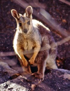
- Black-footed Rock Wallabies
- Very common around rocky gorges.
- Best spots: Simpsons Gap, Ormiston Gorge, Serpentine Gorge.
- Usually active at dawn and dusk.
- Euros (Common Wallaroos)
- Seen around cliffs, rocky slopes, and arid hillsides.
- Often resting in shade during the day.
- Red Kangaroos
- The classic outback roo.
- Most often seen on the flats and open plains on drives between gorges.
- Dingoes
- Common throughout the ranges.
- Often seen near campgrounds in the early morning.
- Respectful distance recommended.
- Western Bowerbird
- Very common in the West MacDonnell Ranges.
- Look for their decorated bowers near picnic areas (pebbles & white objects).
- Budgerigars
- Can appear in huge flocks after good rainfall.
- Zebra Finches
- Always around waterholes.
- Australian Ringnecks, Cockatoos, Galahs
- Abundant and photogenic.
- Birds of Prey
- Wedge-tailed eagles
- Black kites
- Brown falcons
- Often seen soaring above the ranges.
- Painted Finch, Spinifex Pigeon, Peregrine Falcon
- More specialised but regularly encountered on rocky country.
- Reptiles You May Spot
- Perentie (Australia’s largest monitor lizard)
- BIG, impressive, and fairly common.
- Likes rocky outcrops in the West MacDonnell Ranges.
- Centralian Blue-tongue Lizard
- Slow-moving, friendly-looking lizard.
- Thorny Devil (rare but possible)
- Best spotted after rain and on warm mornings.
- Bearded Dragons & Other Agamids
- Common near walking tracks, sunning on rocks.
- Perentie (Australia’s largest monitor lizard)
- Snakes
- Including woma pythons, whip snakes, and desert browns.
- Mostly avoid contact and are rarely seen unless you’re quiet and patient.
- Night-Time Wildlife (if you’re camping)
- Barn owls & boobooks
- Inland small mammals such as dunnarts
- Possums around gorges
- Bats around waterholes
- Dingoes wandering quietly through camps (don’t feed them)
- Night drives around the ranges (or just walking to the toilet block!) can reveal plenty of hidden wildlife.
- Aquatic Life in Waterholes
- Spangled perch
- Desert rainbowfish
- Tadpoles and frogs after rain
- Great places: Ellery Creek Big Hole, Ormiston Gorge, Redbank Gorge.
- Rare or Special Species
- These are harder to spot, but the MacDonnells are prime habitat:
- Black-footed rock wallaby (saw earlier, common but special)
- Central Rock-rat (critically endangered, rarely seen)
- Rufous-crowned emu-wren (birdwatching bucket-list species)
- Dusky grasswren (one of Australia’s most sought-after birds)
- Woma python (beautiful but rarely encountered)
- Photographers and birders especially prize the grasswrens and emu-wrens.
- These are harder to spot, but the MacDonnells are prime habitat:
What Makes the Flora Special?
- Many species are endemic to Central Australia.
- Plants show extreme adaptations—deep roots, waxy leaves, fire resistance, and seed dormancy that lasts decades.
- After rainfall, dormant seeds burst into fast growth, transforming the landscape.
Swimming
You can swim in several beautiful, permanent or semi-permanent waterholes throughout the West MacDonnell and East MacDonnell Ranges. These are some of the most scenic swimming spots in Central Australia—cool, clear, and surrounded by towering red cliffs.
West MacDonnell Range
- Ellery Creek Big Hole
- One of the most popular and reliable swimming waterholes.
- Deep, cold water year-round
- Large sandy beach area
- Great for picnics and photography
- One of the safest and easiest access points for all vehicles
- Ormiston Gorge
- Famous for its stunning gorge walls and clear water.
- Permanent waterhole
- Swimmable most of the year
- Can be cold even in summer
A short, easy walk takes you to the main pool.
- Redbank Gorge
- An adventurous, canyon-style swim.
- Very cold water
- Often requires swimming through narrow chasms
- Inflatable tube recommended
- Best for strong swimmers; extremely scenic.
- Glen Helen Gorge
- A wide, beautiful waterhole at the mouth of the gorge.
- Swimmable depending on recent conditions
- Scenic backdrop with Mt Sonder nearby
(Note: Facilities depend on whether the lodge is operating at the time.)
- Serpentine Gorge
- A peaceful, less-visited waterhole.
- Usually shallow but swimmable after rain
- Quiet, excellent atmosphere
A short walk from the car park leads to the pool.
East MacDonnell Range
- Trephina Gorge
- Not usually deep enough for proper swimming—more for wading—
but after rain you may find small pools.
- Not usually deep enough for proper swimming—more for wading—
- John Hayes Rockhole
- A series of pools and rockholes.
- Often swimmable after good rainfall
- Rocky access, 4WD recommended, getting there is part of the adventure.
- The Chain of Ponds Walk loops through the area for those who want to explore more, passing small pools and dramatic rock features.
- Beautiful and secluded
Important Notes for Swimming in Central Australia
- Water is very cold, even in summer, especially at Ormiston and Redbank.
- Always check local conditions—water levels vary by season.
- Some areas may temporarily close due to flooding or cultural reasons.
- Never jump into unknown water; it can be shallow or have submerged rocks.
Namatjira Drive
One of Central Australia’s most scenic roads, running through the heart of the West MacDonnell Ranges and linking many of the region’s most iconic natural attractions. Named after the famous Western Arrernte artist Albert Namatjira, the sealed road stretches west from Alice Springs and forms part of the Red Centre Way loop. It’s an easy and rewarding drive that showcases the deep red quartzite cliffs, wide desert plains, and dramatic gorges that define the West MacDonnell Range.
The road is accessible for 2WD vehicles, with many short walks, waterholes, and lookouts located only minutes from the main route. With endless photographic viewpoints, abundant wildlife, and some of the NT’s best sunrise and sunset locations, Namatjira Drive is both a practical route and a destination in itself—perfect for day trips or multi-day adventures through the West MacDonnell Range.
Ross Highway
The gateway to the East MacDonnell Ranges, offering a quieter, less-travelled alternative to the West MacDonnell Range while still delivering dramatic scenery, cultural sites, and hidden gorges. Starting just outside Alice Springs, the sealed highway winds through rolling hills, red rock formations, and wide desert plains, gradually revealing the rugged beauty of the eastern ranges. It’s an easy drive suitable for all vehicles, with many key sites located just off the road, making it ideal for half-day or full-day trips. With fewer crowds and a strong sense of space, the Ross Highway is one of Central Australia’s most peaceful and rewarding scenic drives.
Larapinta Trail
The Larapinta Trail is one of Australia’s premier long-distance walking routes, stretching 221 km along the spine of the West MacDonnell Ranges from Alice Springs to the summit of Mt Sonder.
Known for its dramatic red-rock landscapes, ancient geology, and sweeping desert vistas, the trail offers a true outback wilderness experience. It is divided into 12 sections, each with its own character—from sheltered river valleys and steep quartzite ridges to deep gorges, ghost gum woodlands, and wide open plains. The terrain is rugged but incredibly rewarding, with well-marked tracks, water tanks at trailheads, and established campsites, making it a world-class trek for both multi-day hikers and section walkers.
What makes the Larapinta Trail special is the sense of remoteness and immersion in Central Australia’s natural and cultural heritage. Wildlife sightings are frequent—rock wallabies, perenties, wedge-tailed eagles—and the changing colours of the ranges at sunrise and sunset are unforgettable.
Walkers can choose anything from short day walks to the full end-to-end journey, which usually takes about 12–16 days. The traditional lands of the Arrernte people, the trail passes many culturally significant sites, and visitors are encouraged to walk with respect. With its rugged beauty, challenging terrain, and deep sense of place, the Larapinta Trail is considered one of the great desert treks of the world.
Tips for Visiting Cultural Sites Respectfully
- Stay on marked paths to avoid disturbing sacred ground.
- Don’t enter restricted areas or climb on significant formations.
- Don’t remove ochre, stones, or cultural materials.
- Photography is welcome at most sites, but always respect signs that prohibit it.
- Take a moment to learn the stories—many sites have excellent interpretive displays.
Here are some of the most significant Indigenous cultural sites you can visit in both the East and West MacDonnell Ranges. All lie within Arrernte Country, and each place has deep spiritual importance connected to Dreaming stories, rock art, and ancient cultural practices. Visitors are welcome but should walk respectfully, stay on paths, and observe any cultural signage.
West MacDonnell Ranges – Cultural Sites
- Simpsons Gap (Rungutjirpa)
- A sacred site for the Arrernte people, associated with important creation stories.
- The towering gorge walls and permanent waterhole make it one of the most atmospheric cultural places in Central Australia.
- Standley Chasm (Angkerle Atwatye)
- A privately owned Aboriginal site run by the local Traditional Owners.
The chasm glows brilliant red at midday when the sun shines directly into its narrow walls. - The site has strong women’s cultural significance and a visitor centre with cultural information.
- A privately owned Aboriginal site run by the local Traditional Owners.
- Ochre Pits
- An ancient quarry used for thousands of years by Aboriginal people to collect ochre for ceremonies, body painting, trading, and healing.
- The colourful cliff face—red, yellow, white, brown—tells stories of traditional ochre use and its value across Central Australia.
- Ormiston Gorge / Ormiston Pound
- Home to important Arrernte stories, including ancestral beings who shaped the landscape.
- The area is rich with cultural history and is surrounded by significant songlines.
East MacDonnell Ranges – Cultural Sites
- Emily Gap (Anthwerrke)
- A major Arrernte sacred site and one of the most important places for the Caterpillar (Yeperenye) Dreaming.
- Rock art inside the gap depicts the caterpillar ancestors who created parts of the MacDonnell Ranges.
- Jessie Gap (Yeperenye)
- Linked to Emily Gap through the same Caterpillar Dreaming story.
- Features rock art and a peaceful dry riverbed setting.
- Corroboree Rock (Ewaninga)
- A striking, sacred quartzite formation connected to ancient ceremonial use.
- Visitors can walk around the formation but are asked not to climb it.
- N’Dhala Gorge (Irrerlirre)
- One of the richest rock-art sites in Central Australia.
- Over 6,000 petroglyphs—ancient engravings—line the gorge walls, along with significant cycads and sacred sites.
- Accessed via a rough 4WD track.
- Arltunga Historical Reserve
- While primarily known as a historic gold-mining town, Arltunga is also within a region that holds long-standing Aboriginal significance. Interpretive signs explain the traditional connections to the area long before European settlement.
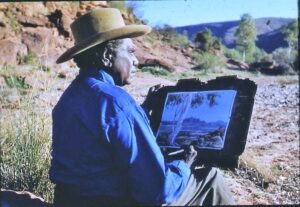
Albert Namatjira
Albert Namatjira created many of his most famous paintings within the MacDonnell Ranges, the landscape that inspired him throughout his life. He is best known for his distinctive watercolours that capture the light, colour, and spirit of Arrernte Country—particularly the red quartzite cliffs, ghost gums, and sweeping ranges of Central Australia.
Where He Painted in the Ranges
- Simpsons Gap
- Standley Chasm
- Ormiston Gorge
- Glen Helen Gorge
- Ellery Creek area
- Mt Sonder region
- Along Namatjira Drive and the Finke River
Major Works Featuring the MacDonnell Ranges
- “Ghost Gum, MacDonnell Ranges”
- One of his most iconic images.
- Features a luminous white ghost gum set against the deep red walls of the ranges. This composition became synonymous with Namatjira and Central Australian art.
- “Central Australian Landscape”
- Painted from various locations across the West MacDonnell Ranges.
- Shows the rolling ridges, dry riverbeds, and distinctive blue-purple shadows cast by the mountains.
- “Haast’s Bluff” and “Mt Sonder” Series
- While Haasts Bluff is slightly west of the main MacDonnell Ranges, the Mt Sonder paintings often feature the western end of the ranges and are among his most celebrated works.
- “Simpsons Gap”
- A beautifully rendered watercolour showing the steep, glowing cliffs of the gap.
Simpsons Gap (Rungutjirpa) was one of Namatjira’s favourite subjects.
- A beautifully rendered watercolour showing the steep, glowing cliffs of the gap.
- “Ormiston Gorge” & “Ormiston Pound” Paintings
- The bright rock walls, ghost gums, and open bowl of Ormiston Gorge appear in several of his works.
- “Glen Helen Gorge”
- He often painted Glen Helen and the surrounding ridges, capturing reflections in the Finke River and the towering red rock faces.
- “Hermannsburg Landscapes”
- Although technically centred around his home area at Ntaria (Hermannsburg), many paintings in this collection feature the southern view of the MacDonnell Ranges backdrop.
Common Elements Albert Namatjira Depicted in the MacDonnell Ranges
- Vibrant ghost gums with white or blue-tinged bark
- Layered red quartzite cliffs glowing in sunlight
- Rolling ridges and distant mountains
- Shaded gorges such as Ormiston and Simpsons
- Sandy creek beds lined with red gums
- Blue–purple shadows that became a signature of his style
- He had a rare ability to convey depth, heat, and the spiritual presence of the land, transforming everyday desert scenes into luminous watercolours.
Maps and Guides
“Plan your Central Australia adventure by using our extensive collection of online maps, brochures and guides. Feel free to download them to your devices for easy offline access when you’re on the road, or print them off if you prefer a physical copy.”2
Click on the link below to take you directly to the maps, brochures and guides:
https://www.discovercentralaustralia.com/visitor-information/maps-guides
Useful Links
- Tjoritja / West MacDonnell Ranges: https://northernterritory.com/alice-springs-and-surrounds/destinations/tjoritja–west-macdonnell-national-park
- Tjoritja / West MacDonnell National Park: https://nt.gov.au/parks/find-a-park/tjoritja-west-macdonnell-national-park
- West MacDonnell Ranges: https://www.discovercentralaustralia.com/regions/west-macdonnell-ranges
- A Complete East MacDonnell Ranges Trip: https://www.discovercentralaustralia.com/things-to-do/np-reserves/complete-east-macs-trip
- The ultimate guide to exploring the West MacDonnell Ranges: https://www.australiantraveller.com/nt/red-centre/guide-to-the-west-macdonnell-ranges/
- Explore the Northern Territory’s West MacDonnell Ranges: https://hemamaps.com/blogs/iconic-destinations/west-macdonnell-ranges?srsltid=AfmBOooyFP5iTkl-TdN_g8pGol5u2i9IaRHvwIJ0WbeBraaKtxu3DfzZ
- Your guide to the West MacDonnell Ranges: https://www.travelgateway.com.au/visiting-the-west-macdonnell-ranges
- A Thrilling 2WD Journey Through The West MacDonnell Ranges: https://norther.com.au/ranges-2wd-journey/
- The Ultimate West MacDonnell Ranges Itinerary: https://nigelandsueadventures.com/west-macdonnell-ranges-itinerary/
- A Guide to Exploring the East MacDonnell Ranges: https://beyondwildplaces.com/guide-to-exploring-east-macdonnell-ranges/
- West MacDonnell Ranges: The Ultimate Guide: https://thelittleadventurers.net/5-unforgettable-gems-in-the-west-macdonnell-ranges-you-must-see/?srsltid=AfmBOoo_OrGCv35qoQJdJF-CdDkkdi3LAcMxRSUma4K4KKDH6FT7_aDz
- East MacDonnell Ranges: https://northernterritory.com/alice-springs-and-surrounds/destinations/east-macdonnell-ranges
- Things to Do in the West MacDonnell Ranges: https://www.discovercentralaustralia.com/things-to-do/west-macdonnell-ranges
- Walking and cycling in Tjoritja / West MacDonnell National Park: https://nt.gov.au/parks/find-a-park/tjoritja-west-macdonnell-national-park/walking-and-cycling-in-tjoritja-west-macdonnell-national-park
- Larapinta Trail: https://www.larapintatrail.com.au/
- A Week Away: The West McDonnell Ranges & Kings Canyon: https://www.club4x4.com.au/week-away-west-mcdonnell-ranges-kings-canyon/
- West MacDonnell Ranges, NT: Red Centre Hot Spot: https://www.4x4australia.com.au/explore/nt/west-macdonnell-ranges-nt-red-centre-hot-spot
- The best camping spots in the West MacDonnell Ranges (Tjoritja): https://unsealed4x4.com.au/the-best-camping-spots-in-the-west-macdonnell-ranges-tjoritja/
- West Macdonnell Ranges, Northern Territory: https://www.4x4australia.com.au/explore/nt/west-macdonnell-ranges-northern-territory
- Complete Guide to the East MacDonnell Ranges: https://nigelandsueadventures.com/east-macdonnell-ranges/
- Camping in the East MacDonnell Ranges: https://www.discovercentralaustralia.com/things-to-do/camping/east-macdonnell-ranges-camping
- Exploring the Scenic MacDonnell Ranges: A Hema Maps Guide to Free Camping in The Northern Territory: https://hemamaps.com/blogs/iconic-destinations/exploring-the-scenic-macdonnell-ranges-a-hema-maps-guide-to-free-camping-in-the-northern-territory
- West MacDonnell Ranges Camping: https://www.discovercentralaustralia.com/things-to-do/camping/west-macdonnell-ranges-camping
- Camping in Tjoritja / West MacDonnell National Park: https://nt.gov.au/parks/find-a-park/tjoritja-west-macdonnell-national-park/camping
- Trephina Gorge Nature Park: https://nt.gov.au/parks/find-a-park/trephina-gorge-nature-park
- Parks pass for national parks and reserves: https://nt.gov.au/parks/parks-pass
- Ochre Pits: https://northernterritory.com/alice-springs-and-surrounds/see-and-do/ochre-pits
- Ellery Creek Big Hole: https://nt.gov.au/parks/find-a-park/tjoritja-west-macdonnell-national-park/ellery-creek-big-hole
- Experience an icon of Central Australia: https://standleychasm.com.au/
- Serpentine Gorge: https://northernterritory.com/alice-springs-and-surrounds/see-and-do/serpentine-gorge
- Ormiston Gorge: https://nt.gov.au/parks/find-a-park/tjoritja-west-macdonnell-national-park/ormiston-gorge
- Glen Helen Gorge: https://northernterritory.com/alice-springs-and-surrounds/see-and-do/glen-helen-gorge
- Redbank Gorge: https://nt.gov.au/parks/find-a-park/tjoritja-west-macdonnell-national-park/redbank-gorge
- Mt Sonder (Rutjupma): https://northernterritory.com/alice-springs-and-surrounds/see-and-do/mt-sonder-rutjupma
- A Guide to Hiking Mount Sonder: https://www.discovercentralaustralia.com/things-to-do/walks-hikes/a-guide-to-hiking-mount-sonder
- Corroboree Rock Conservation Area: https://nt.gov.au/parks/find-a-park/corroboree-rock-conservation-area
- N’Dhala Gorge Nature Park: https://nt.gov.au/parks/find-a-park/ndhala-gorge-nature-park
- Arltunga Historical Reserve: https://nt.gov.au/parks/find-a-park/arltunga-historical-reserve
- Ruby Gap Nature Park: https://nt.gov.au/parks/find-a-park/ruby-gap-nature-park
- Simpsons Gap: https://nt.gov.au/parks/find-a-park/tjoritja-west-macdonnell-national-park/simpsons-gap
- Serpentine Chalet Dam: https://northernterritory.com/alice-springs-and-surrounds/see-and-do/serpentine-chalet-dam
- Serpentine Chalet Bush Camping area: https://northernterritory.com/alice-springs-and-surrounds/see-and-do/serpentine-chalet-bush-camping-area
- Authentic Outback Charm for Unforgettable Gatherings: http://rossriverresort.com.au/
- Hale River Homestead at Old Ambalindum: https://www.haleriverhomestead.com.au/
- SqueakyWindmill: https://www.squeakywindmill.com/
- Safety in Tjoritja / West MacDonnell National Park: https://nt.gov.au/parks/find-a-park/tjoritja-west-macdonnell-national-park/safety
- Safety information for visiting the Northern Territory: https://northernterritory.com/plan/useful-information/safety-information
- The Aboriginal Areas Protection Authority: http://aapant.org.au/
- Protection of Aboriginal sacred sites in the NT: https://www.edo.org.au/publication/protection-of-aboriginal-sacred-sites-in-the-nt/
- Maps and Guides: https://www.discovercentralaustralia.com/visitor-information/maps-guides
- West MacDonnell Ranges-Namatjira: https://mainlanddiscoveries.wordpress.com/2017/11/27/west-macdonnell-ranges-namatjira/
- https://www.discoveryholidayparks.com.au/caravan-parks/northern-territory/macdonnell/glen-helen/see-do?propertyCode=CGLE&arrive=2025-11-27&depart=2025-11-28&adults=2&kids=0&infants=0&sort=price-desc&maxSearchResults=30 ↩︎
- https://www.discovercentralaustralia.com/visitor-information/maps-guides ↩︎