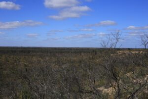
Wyperfeld National Park, located in north-west Victoria, is one of Australia’s great inland wilderness areas, showcasing the beauty and diversity of the Mallee region. The park is known for its vast open landscapes, ancient dune systems, and rich variety of native plants and wildlife. Visitors can explore its scenic drives, peaceful walking tracks, and remote campgrounds, offering a true outback experience. Whether you’re camping under the stars, spotting kangaroos and emus, or simply enjoying the quiet of the bush, Wyperfeld provides an ideal escape into nature’s heart.
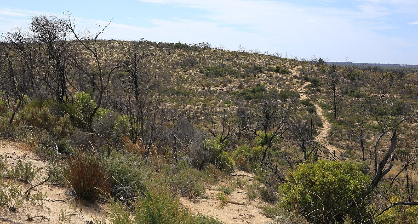
Wyperfeld National Park spans over 360,000 hectares in north-west Victoria, making it one of the largest national parks in the state. The park lies within the Mallee region and forms part of a vast system of ancient dry lake beds and sand dunes that were once filled by the now-vanished Wimmera River system.
The area has a long and rich history—Aboriginal peoples, including the Latji Latji, Ngintait, and Wergaia, have lived here for thousands of years, relying on the park’s semi-arid landscapes for food, water, and shelter. European settlers began grazing stock in the late 1800s, and Wyperfeld was declared a national park in 1921, making it one of Victoria’s oldest.
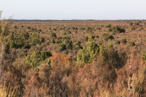
Vegetation in the park reflects its Mallee environment, with mallee eucalypts, buloke, belah, and cypress pine woodlands dominating the landscape. In wetter areas, you’ll find black box and river red gum trees along the creeks and ephemeral lakes. The park is also home to a remarkable variety of wildflowers, particularly after rain, adding vibrant colour to the desert scenery.
Wyperfeld National Park supports an impressive range of native wildlife, adapted to its dry Mallee environment.
Commonly seen animals include red kangaroos, western grey kangaroos, emus, and echidnas, as well as smaller mammals such as dunnarts and mallee ningaui—tiny carnivorous marsupials unique to this region. Reptiles are also abundant, with bearded dragons, blue-tongue lizards, goannas, and various snakes thriving in the sandy terrain.
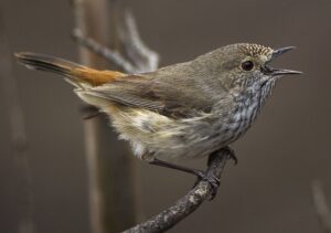
The park is a haven for birdwatchers, with over 200 recorded species. Notable birds include the mallee fowl, a rare ground-dwelling bird that builds large nesting mounds, as well as pink cockatoos, galahs, apostlebirds, wedge-tailed eagles, and major mitchell’s cockatoos. During wetter periods, seasonal lakes attract pelicans, ducks, and herons.
This diversity of wildlife makes Wyperfeld a special destination for nature enthusiasts, photographers, and anyone interested in experiencing the richness of Australia’s inland ecosystems.
The best time to visit is autumn through spring (April to October). During these months, the weather is mild, the days are comfortable for walking and exploring, and the park’s wildlife is more active. Winter and early spring are especially good for birdwatching, as many species migrate into the area when water is present in the lakes and wetlands.
Summer, by contrast, can be extremely hot—often exceeding 40°C—making outdoor activities challenging and sometimes unsafe, so it’s generally the least suitable time to visit.
If you plan on visiting, please download the trip intention form before you go. Please see the PDF below to download.
Related Sites listed in Parks Victoria – Wyperfeld National Park, go to the website to download the PDFs, the first link listed in the Useful Links below.
- Gunners timber well (Wyperfeld National Park, Wimmera River Heritage River)
- Casuarina Loop Walk (Wyperfeld National Park, Wimmera River Heritage River)
- Western Dune Lookout Walk (Wyperfeld National Park, Hopping Mouse Hill Remote and Natural Area, Wimmera River Heritage River)
- Kelly’s Lookout (Wyperfeld National Park)
- O’Sullivlans Lookout (Wyperfeld National Park)
- Tyakil Walking Track (Hopping Mouse Hill Remote and Natural Area, Wyperfeld National Park, Wimmera River Heritage River)
- Black Flat (Wyperfeld National Park, Wimmera River Heritage River)
- Northern Remote Hike-in Camping Area (Wimmera River Heritage River, Wyperfeld National Park)
- Snow Drift Camping Area (Wyperfeld National Park)
- Casuarina Camping Area (Wimmera River Heritage River, Wyperfeld National Park)
- Rabbiters hut (Wimmera River Heritage River, Wyperfeld National Park)
- Round Swamp Camping Area (Wyperfeld National Park)
- Eastern Lookout (Wyperfeld National Park, Wimmera River Heritage River)
- Wonga Camping Area (Wimmera River Heritage River, Wyperfeld National Park)
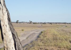
Popular 4WD Tracks
- Meridian Track
- One of the main north–south routes through the park.
- Connects Wonga Campground (south) to Wyperfeld’s northern section near Underbool.
- Offers a mix of soft sand dunes, clay pans, and mallee scrub.
- Suitable for experienced 4WDers — traction can be challenging in dry, sandy sections.
- Dattuck Track
- Runs through central areas of the park and links to the Meridian Track.
- Known for rolling dunes and scenic views across mallee woodlands.
- Great for spotting kangaroos, emus, and birdlife.
- Chinaman Well Track
- Shorter, scenic route leading to Chinaman Well, an old watering point used by early settlers.
- Good introductory 4WD track with sandy but manageable conditions.
- Ideal for day trips from Wonga Campground.
- Casuarina Track
- A more remote, northern track leading toward Murray-Sunset National Park.
- Suitable for experienced 4WDers due to soft sand and isolation.
- Offers the chance to explore true wilderness areas away from crowds.
- Eastern Lookout Track
- Leads to Eastern Lookout, one of the best viewpoints in the park.
- Short but sandy — perfect for sunset or sunrise photography.
- 4WD recommended, especially after rain.
Why 4WD Here?
- Wyperfeld offers a true outback experience close to Melbourne (about 450 km northwest). It’s quieter and more accessible than many desert parks, making it ideal for those wanting to practice 4WD skills in sandy, remote terrain with minimal crowds.
- The combination of dunes, salt lakes, and mallee forests gives a real taste of Australia’s inland wilderness.
4WD Tips
- Tyre pressure: Lower to around 20–26 psi for sandy tracks to improve traction.
- Navigation: Carry a paper map or an offline GPS — reception is limited.
- Vehicle: High-clearance 4WD essential; AWD vehicles may struggle in deep sand.
- Supplies: Bring extra water, food, and fuel — no fuel available inside the park. The nearest fuel stops are at Hopetoun, Patchewollock, or Underbool.
- Driving technique: Keep momentum in soft sand, avoid sudden braking or sharp turns, and use low-range gears in dunes.
- Weather: Best from April to October; summer heat can exceed 40°C. Avoid after heavy rain, as clay sections can become impassable.
- Wildlife: Watch for kangaroos, emus, echidnas, and mallee birds — most active at dawn and dusk.
Camping Options
- Wonga Campground: Main campsite, suitable for 2WD access, with toilets, picnic tables, and fireplaces.
- Snowdrift Campground: 4WD access only; near the park’s largest dune, great for sandboarding and stargazing.
- Casuarina Campground: Remote bush camp accessible via 4WD, offering peace and solitude.
Key Attractions
- Eastern Lookout
- Offers panoramic views across the desert-like landscape of the park. Ideal for sunrise or sunset, with opportunities to spot kangaroos and emus roaming in the wild.
- Kelly’s Lookout
- Another lookout point that provides sweeping views of the park’s terrain.
- A great spot for photography, especially of the sand dunes and woodland.
- O’Sullivlans Lookout
- More scenic vantage point within the park.
- Good for spotting wildlife and taking in the expansive semi-arid landscape.
- Tyakil Nature Walk
- A ~4.8 km loop from the Black Flat car park.
- This self-guided walk showcases typical mallee country: porcupine grass, sand dunes, and native bushes.
- Best wildlife viewing is at dawn or dusk (e.g., kangaroos, emus, possums).
- Wyperfeld Discovery Walk
- A 4 km interpretive walk starting from Wonga Campground.
- You pass through black box woodlands, climb a dune, and reach Mount Mattingley lookout, which offers 360° views over clay pans and the broader park.
- Along the walk, you might spot the “Devil’s Pools” (seasonal clay pans that fill in wetter years).
- Desert Walk
- A 4.6 km circuit trail through sand dunes, heathland, and mallee woodland.
- Wildlife such as kangaroos and emus are commonly seen, though visitors should be mindful of snakes.
- Wildlife & Birdwatching
- Over 200 bird species have been recorded in the park.
- Common mammals: western grey kangaroos, emus.
- Unique plant life: around 450 species of native plants across different habitats (dunes, floodplains, woodlands)
- Seasonal Wildflower Displays
- In wetter seasons (especially spring), dormant plant seeds germinate, and the park can bloom with wildflowers.
- This transformation makes the otherwise dry landscape very beautiful and biologically vibrant.
Plant Life
Wyperfeld National Park supports a wide variety of plant life adapted to its semi-arid Mallee environment.
- Mallee Woodlands
- The dominant vegetation in the park, made up of multi-stemmed mallee eucalypts such as red mallee, blue mallee, white mallee, and black box. These hardy trees thrive in sandy soils and low rainfall.
- Spinifex Grasslands
- Large areas are covered in spinifex (porcupine grass), which forms dense hummocks and provides shelter for many small animals and reptiles.
- Casuarina and Buloke Woodlands
- In slightly heavier soils, you’ll find buloke and slender cypress pine, forming open woodlands important for bird life.
- Chenopod Shrublands
- Saltbush and bluebush species grow in the drier, more saline parts of the park, adding to the diversity of arid-zone vegetation.
- Heathlands
- In some sandy rises you’ll encounter heath species such as tea-trees, banksias, and grevilleas, especially after rain.
- Wildflowers
- After good seasonal rainfall, Wyperfeld bursts with colour from everlastings, poached-egg daisies, lilies, and various small annuals that rejuvenate the landscape.
Water
Wyperfeld National Park doesn’t have permanent rivers or lakes, but it contains an important ephemeral (seasonally filled) wetland system that comes to life after significant rainfall.
- Lake Albacutya
- A large, normally dry lake at the southern end of the park, part of the Wimmera–Mallee wetland system. It only fills during major flood events but is internationally recognised for its ecological importance.
- Lake Brambruk (formerly Lake Wonga)
- Another major ephemeral lake within the park that holds water only in very wet years, supporting birds and vegetation when full.
- Outlet Creek
- A long, dry creek bed that carries water north through the park during rare flood events. It connects Lake Albacutya to a chain of northern lakes.
- Northern Lake System
- A series of shallow basins, including Lake Agnes, Lake Martin, and Lake Merrimanj, which occasionally receive water from Outlet Creek. These usually remain dry but can support birdlife and temporary wetlands after rainfall.
- Black Flat
- A claypan and surrounding low-lying area that can hold water briefly after local rain.
- Temporary Wetlands and Soak Areas
- Scattered across the park, these small depressions fill after storms, supporting frogs, birds, and bursts of plant growth.
Useful Weblinks
- Wyperfeld National Park: https://www.parks.vic.gov.au/places-to-see/parks/wyperfeld-national-park
- Wyperfeld Discovery Walk: https://bushwalkingvictoria.org.au/bwv_walk_directory/wyperfeld-discovery-walk/
- Wyperfeld National Park: https://vnpa.org.au/parks/wyperfeld-national-park/
- Wyperfeld National Park: https://www.roamingtheoutback.com/2015/07/wyperfeld-national-park/
- Wyperfeld National Park: A 4WD and camping paradise in Victoria’s outback: https://www.4x4australia.com.au/explore/vic/wyperfeld-national-park
- 4×4 Trip to Wyperfeld National Park, Vic: https://www.4x4australia.com.au/explore/vic/4×4-trip-to-wyperfeld-national-park-vic
- Wyperfeld National Park: A Mallee Wilderness: https://evendo.com/locations/australia/mallee/attraction/wyperfeld-national-park
- Eastern Lookout (Wyperfeld National Park, Wimmera River Heritage River): https://www.parks.vic.gov.au/places-to-see/sites/eastern-lookout
- The Friends of Wyperfeld National Park: https://friendsofwyperfeldnp.org.au/
- Walks in Wyperfeld National Park: https://www.trailnavigator.com.au/vic/national-parks/wyperfeld-national-park
- Safety in nature: https://www.parks.vic.gov.au/get-into-nature/safety-in-nature