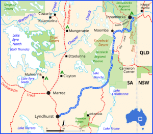
The Strzelecki Track is a remote outback route in South Australia that runs between Lyndhurst and Innamincka, crossing arid desert plains, gibber country, and sections of the Strzelecki Desert. Originally created as a stock route in the late 1800s, it passes through country rich in pastoral history, Aboriginal heritage, and early exploration stories. Today it’s a popular adventure drive for travellers seeking wide-open landscapes, big skies, and a true outback experience. Although much of the track is now maintained and often suitable for high-clearance 2WD in dry conditions.
The Strzelecki Track has its origins in the late 19th century as an outback stock route forged by the explorer and drover Harry Redford (Captain Starlight), who famously drove stolen cattle through this harsh region in the 1870s, proving the route’s viability. The track later became an important corridor for moving livestock between the Channel Country of Queensland and the railhead at Lyndhurst in South Australia. It follows terrain shaped by ancient river systems and crosses land traditionally belonging to Aboriginal groups including the Yandruwandha and Yawarrawarrka peoples, whose trade routes long pre-dated European use. In the 20th century, the track gained further significance with the development of oil and gas fields in the Cooper Basin, bringing maintenance upgrades and more reliable access. Today its history is still evident in the remnants of early stations, exploration routes, and the enduring sense of isolation that defined life along the track.
Travelling the track offers a mix of classic outback scenery, desert wildlife, and historic sites. Here’s what you can expect to see along the way:
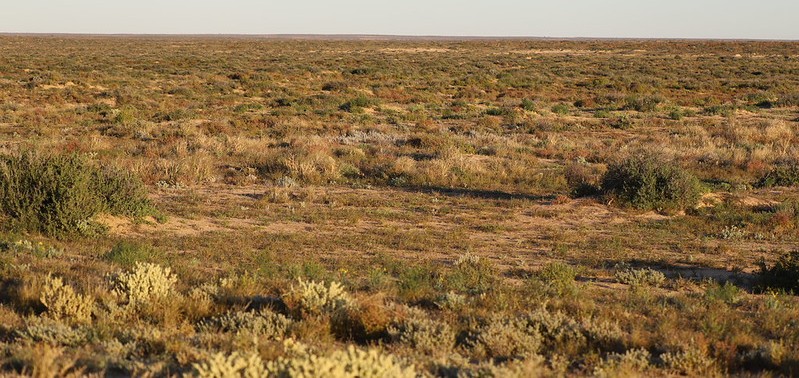
- Sweeping desert landscapes — endless gibber plains, red sand dunes of the Strzelecki Desert, and big outback skies.
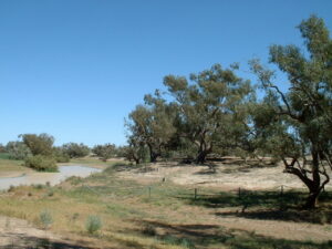
- Cooper Creek region — a rare green corridor of river gums, waterholes, and birdlife near Innamincka.
- Wildlife — kangaroos, emus, wedge-tailed eagles, and sometimes dingoes; at dawn and dusk the plains can be full of animals.
- Historic sites — ruins of old homesteads and stock routes, early oil and gas exploration infrastructure, and markers linked to explorers such as Burke and Wills near Innamincka.
- Mound springs — natural artesian springs (such as Montecollina Bore) forming surprising oases in the desert, often attracting birds and animals.
- Innamincka Regional Reserve — remote country with access to the Burke & Wills Dig Tree (a bit off the main route), the Innamincka township, and Cooper Creek waterholes.
- Big sky sunsets — the desert colours at sunrise and sunset are a highlight of the drive.
Highlights (Lyndhurst → Innamincka)
- Lyndhurst
- Small outback town and the official start of the track.
- Nearby attractions include the Ochre Cliffs, traditionally used by Aboriginal people for ceremonial ochre.
- Lyndhurst Hotel
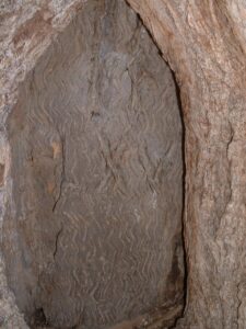
- Talc Alf an outback artist near Lyndhurst known for carving bold, symbolic sculptures from talc stone that reflect Australian history, identity, and bush humour.
- Farina Ruins (short detour)
- A partially restored 19th-century outback township.
- If you’re travelling in winter, the volunteers run a bakery in the old underground oven, generally open for about 8 weeks each year, typically from late May to late July.
- Mount Lyndhurst Station area
- Good area for spotting rare birds like the chestnut-breasted whiteface.
- Classic gibber and saltbush country.
- Strzelecki Desert & Gibber Plains
- Vast, empty landscapes with low dunes, gibber stones, and wide horizons.
- Kangaroos, emus, and wedge-tailed eagles are common.
- Montecollina Bore
- One of the best stops on the whole track.
- A hot artesian bore forming a small desert oasis, attracting birds and wildlife.
- Update: “Sadly, the borehead was capped and is now dry.“1
- Popular informal camping area.
- Moomba Gas Fields (restricted areas)
- Heart of the Cooper Basin oil and gas region.
- Travellers remain on the public road, but you’ll see industrial infrastructure that tells an important part of the region’s modern history.
- You must stay on the public road — no access to private roads or infrastructure.
- Strzelecki Creek Crossing
- Seasonal creek line with occasional waterholes after rain.
- Good place to stretch your legs and look for birdlife.
- Innamincka Regional Reserve (approaching Innamincka)
- As you near Innamincka, the desert gives way to the Cooper Creek floodplain, a green corridor full of birdlife and river gums.
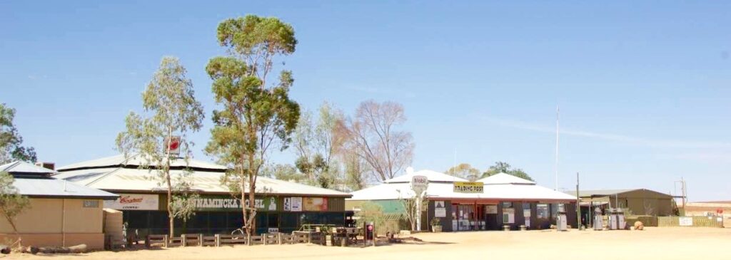
- Innamincka Township
- A tiny but iconic outback settlement.
- Cold drinks at the Innamincka Hotel, fuel, basic supplies.
- Cooper Creek & Burke & Wills Sites (short detours)
- Dig Tree (via Nappa Merrie, QLD) – technically off the Strzelecki Track, but many travellers visit from Innamincka.
- Burke’s Grave and Wills’ Site are closer and easily reached.
- Gorgeous waterholes like Cullyamurra Waterhole, one of the largest permanent waterholes in the region.
Where You Can Camp on the Strzelecki Track
- Montecollina Bore
- A popular informal campground beside the artesian bore — a desert oasis with birdlife, flat ground, and plenty of space.
- Montecollina Dune Area
- Just beyond the bore; open bush camping among low dunes and gibber plains.
- Strzelecki Creek / Various Creek Lines
- Several roadside bush-camp spots where you can pull off near dry creek beds (choose existing sites and avoid vegetation).
- Innamincka Regional Reserve (near the end of the track)
- Multiple designated campgrounds along Cooper Creek, including Cullyamurra Waterhole, Ski Beach, Town Common, and Kings Marker. These require a camping permit.
What to Know
- No facilities at most bush camps — bring all water, toilet setup, and take out all rubbish.
- Check road conditions (rain can close or severely bog the track).
- Camp well away from the road and avoid parking in low spots that can flood.
- Fire restrictions may apply; use existing fire rings only where allowed.
- Permits: Bush camping along the track itself is usually free, but Innamincka Regional Reserve requires a permit.
Places to Stay in Lyndhurst
- Lyndhurst Hotel Motel & Caravan Park — Offers motel rooms (queen/twin), pub-style rooms, powered and unpowered caravan sites, camp kitchen, showers, and laundry.
Places to Stay in Innamincka
- The Innamincka Hotel — Motel-style rooms, eco-friendly accommodation, bar/restaurant, and camping on the Cooper Creek.
- Innamincka Trading Post – Burke Lodge Cabins — Two-bedroom cabins, twin-share rooms and single rooms.
- Innamincka Town Common Campground — Basic camping with toilets, close to the creek and town; pay-by-honesty box.
- Policemans Campground (in Innamincka Regional Reserve) — Remote bush camping near Cooper Creek, with long-drop toilets.
4WD driving on the Strzelecki Track is a classic outback adventure, offering long remote stretches, changing terrain, and wide desert views. The track is usually accessible to high-clearance 2WD in dry conditions, but a 4WD is strongly recommended because rain can quickly turn sections into deep mud, and the gibber plains and corrugations can be tough on vehicles. The route takes you through gibber flats, sandy patches, low dunes, bulldust holes, and creek crossings, especially near Strzelecki Creek and closer to Innamincka. Fuel is limited, so you need to plan carefully, carry extra water, spare tyres, and recovery gear. Weather, road conditions and flood warnings should always be checked before setting out. Despite its remoteness, the track is well-signed and maintained due to oil and gas operations, but it still feels wild, empty and truly “outback,” making it a rewarding 4WD drive for well-prepared travellers.
Most travellers take 1 to 2 days to drive the Strzelecki Track with a few stops along the way.
Typical Timing
- Direct drive: 6–7 hours (Lyndhurst → Innamincka) with minimal stops.
- Relaxed pace with sightseeing: 8–10 hours total driving time over a day.
- Best experience: 1 overnight, making it a 2-day trip with time to enjoy places like Montecollina Bore and Cooper Creek.
Common stop times
- Ochre Cliffs / Talc Alf: 10–20 minutes
- Montecollina Bore: 30–60 minutes (or a great overnight camp)
- Strzelecki Creek stops: 10–15 minutes
- Innamincka surrounds: 1–2 hours or more (especially if visiting waterholes or Burke & Wills sites)
- Day 1: Lyndhurst → Montecollina Bore / Bush Camp
- Morning:
- Start at Lyndhurst; fuel up, stock water, and check your vehicle.
- Quick stop at Ochre Cliffs (~10–15 min) to see the colourful outback rock.
- Optional detour to Farina Ruins (~30–45 min) to explore the historic township.
- Midday:
- Drive through gibber plains and low dunes along the Strzelecki Track.
- Stop for photos of wildlife or desert landscapes.
- Afternoon:
- Reach Montecollina Bore — a natural artesian spring in the desert.
- Set up camp here (informal bush camping) or explore the bore and nearby dunes.
- Enjoy sunset over the desert — great for photography.
- Overnight:
- Montecollina Bore bush camp or dune camping.
- Bring your own water and supplies; no facilities except basic fire rings (check fire restrictions).
- Day 2: Montecollina Bore → Innamincka
- Morning:
- Early start for desert sunrise photos.
- Continue along the Strzelecki Track, stopping at Strzelecki Creek crossings and other roadside wildlife spots.
- Midday:
- Approach Innamincka Regional Reserve — the desert begins to transition to Cooper Creek floodplains.
- Optional short stops at small waterholes and creekside birdwatching.
- Afternoon / Evening:
- Arrive in Innamincka town.
- Visit Cooper Creek, Town Common Campground, or take a short walk to historical sites.
- Check out the Innamincka Hotel for a meal or stay overnight in motel-style rooms or cabins.
Tips for the 2-Day Trip
- Fuel: Carry extra; the nearest fuel after Lyndhurst is Innamincka.
- Water & food: Bring plenty; most stops are remote.
- Vehicle prep: 4WD recommended, carry recovery gear, spare tyres, and check weather/road conditions.
- Camping: Bush camping is allowed at Montecollina Bore; Innamincka has basic campgrounds with toilets.
- Timing: Adjust stops based on interest — wildlife, photography, or historical sites.
Photo-focused 2-day Strzelecki Track itinerary
- Day 1: Lyndhurst → Montecollina Bore / Bush Camp
- Ochre Cliffs (Lyndhurst)
- Bright red, yellow, and white ochre cliffs used by Aboriginal people.
- Best light: morning sun highlighting the colours.
- Quick stop: 10–15 minutes.
- Talc Alf Sculptures (near Lyndhurst)
- Bold outback art carved from talc.
- Great for quirky, human-interest shots.
- Quick stop: 10–20 minutes.
- Farina Ruins (optional detour)
- Restored 19th-century outback town.
- Photo opportunities: old stone buildings, underground bakery, rustic ruins.
- 30–45 minutes.
- Strzelecki Desert Plains
- Vast gibber flats and low sand dunes.
- Wildlife: kangaroos, emus, wedge-tailed eagles.
- Light: sunrise or late afternoon for dramatic shadows.
- Stop as needed along the track.
- Montecollina Bore
- Artesian bore forming a desert oasis.
- Perfect for birdlife, reflections, and sunset shots.
- Overnight camp if desired — minimal light pollution for night photography.
- Day 2: Montecollina Bore → Innamincka
- Strzelecki Creek Crossings
- Seasonal waterholes and creek lines in the desert.
- Wildlife: birds and occasionally kangaroos at waterholes.
- Morning light enhances textures and shadows.
- Cooper Creek Floodplain (approaching Innamincka)
- Lush river gums, waterholes, and birdlife.
- Stunning contrast to the desert plains.
- Best light: afternoon to capture reflections and greenery.
- Innamincka Historical Sites
- Dig Tree (short drive off track) and Burke & Wills Sites.
- Good for historical context shots combined with creek scenery.
- Cullyamurra Waterhole / Town Common
- Ideal for sunset or late afternoon photography.
- Water reflections, birds, and desert-meets-creek landscapes.
Photography Tips
- Wide-angle lens for desert landscapes.
- Telephoto for wildlife and distant dunes.
- Bring a tripod for sunrise, sunset, and night sky shots.
- Golden hour (sunrise/sunset) dramatically enhances desert colours.
Lyndhurst
A small yet iconic outback town in northern South Australia, sitting at the junction of the Strzelecki Track and the Oodnadatta Track, making it an important gateway to the desert. Established in the late 1800s as a railway siding on the old Ghan Railway, Lyndhurst served as a supply stop for pastoral stations and travellers heading north. The town grew with the railway, hosting fettlers, stockmen, and workers who maintained the crucial line linking Adelaide to the interior.
Nearby features like the Ochre Cliffs—used by Aboriginal people for thousands of years—and the surrounding pastoral history add depth to the region’s heritage. Today, Lyndhurst remains a tiny but significant outback stop, offering fuel, a pub, accommodation, and a sense of stepping into Australia’s early overland history.
Innamincka
A tiny but historic outback township in the far northeast corner of South Australia, set on the banks of Cooper Creek, one of the region’s most important inland waterways. The area has been home to the Yandruwandhaand Yawarrawarrka people for tens of thousands of years, with Cooper Creek providing food, trade routes, and cultural significance long before Europeans arrived.
European history here is closely tied to the Burke and Wills expedition of 1860–61, whose tragic story unfolded along Cooper Creek near present-day Innamincka. In the late 1800s and early 1900s, the town developed around Innamincka Station and later became a remote outpost with a police camp, mission, and a Cattle Station Hotel serving drovers, explorers, and mail routes. A Nursing Station, part of the Australian Inland Mission founded by Rev. John Flynn, was established to service isolated pastoral communities.
After declining and being mostly abandoned by the mid-20th century, Innamincka was revived with the discovery of oil and gas fields in the Cooper Basin, bringing new infrastructure, travellers, and services. Today it remains a tiny hub for 4WD adventurers and Strzelecki Track travellers, offering a hotel, trading post, campgrounds, and access to nearby Burke & Wills heritage sites and the beautiful Cooper Creek waterholes.
Travelling the Track
- Road Conditions & Weather
- The track can change dramatically with the weather — rain can close it completely, and bulldust or deep mud can appear quickly.
- Travellers should check SA Outback Roads updates before setting out.
- Fuel & Supplies
- There are no services between Lyndhurst and Innamincka.
- Carry extra fuel, water (at least 10–20L per person), and enough food for delays.
- Communications
- There is no mobile coverage for most of the route.
- A sat phone, PLB, or emergency beacon is highly recommended.
- Wildlife Hazards
- Kangaroos, emus, and cattle are common, especially at dawn/dusk.
- Advise travelling in daylight only.
- Cultural Respect
- Aboriginal history is strong along the route.
- Certain areas near Innamincka are culturally significant — stick to signed tracks and follow local guidelines.
- Best Time to Travel
- Ideal seasons: May to September.
- Summer temperatures can exceed 45°C, making travel dangerous.
The Strzelecki Track is a classic outback drive from Lyndhurst to Innamincka, crossing red dunes, gibber plains and the vast Strzelecki Desert. Once blazed by legendary drover Harry Redford, it’s now a remote 4WD adventure. The journey ends at the lush banks of Cooper Creek, rich in Aboriginal heritage and Burke & Wills history. With big skies, wide horizons and true outback isolation, the Strzelecki Track is one of Australia’s great desert drives.
Useful Websites
- Strzelecki Track Upgrade and Sealing Project: https://dit.sa.gov.au/infrastructure/projects/strzelecki-track-upgrade-and-sealing-project
- Driving the Strzelecki Track: https://hemamaps.com/blogs/iconic-destinations/strzelecki-track?srsltid=AfmBOoqTSRTskcYrRssSDzsIu8f3d-GlW3hISctWcNcyqvSS-4bkaplN
- Strzelecki Track, South Australia: https://www.4x4australia.com.au/explore/sa/strzelecki-track-south-australia
- The Strzelecki Track, South Australia: https://www.odysseytraveller.com/articles/the-strzelecki-track-south-australia/
- Innamincka, SA: https://www.aussietowns.com.au/town/innamincka-sa
- Innamincka: https://hemamaps.com/blogs/iconic-destinations/innamincka?srsltid=AfmBOoo66_5cY5CzcB3FD6zBGZBOTAYboTG6oXWpyfyFMG9X5gqZ06l9
- Lyndhurst, SA: https://www.aussietowns.com.au/town/lyndhurst-sa
- Strzelecki Track Part 2 – Getting there: https://www.snowys.com.au/blog/strzelecki-track-part-2-getting-there/?srsltid=AfmBOooyZooZx8Wxda4UstAde5OAD2W8Z5WosQdXTU9GQM-lo3h2lhea
- Montecollina Bore, Strzelecki Track – Once An Ideal Bush Camp In The Desert: https://topwiretraveller.com/montecollina-bore-strzelecki-track/
- Essential Guide to Driving the Strzelecki Track: https://www.chartandmapshop.com.au/blogs/blog/essential-guide-to-driving-the-strzelecki-track?srsltid=AfmBOor0tjaTl6B6IsHbgJ-5XNtBqA-U024yiepNsykECMzWkpkZRf1e
- The naming of Australia’s Strzelecki Desert: https://nicolealexander.substack.com/p/the-naming-of-australias-strzelecki
- Sir Paul Edmund de Strzelecki (1797–1873): https://adb.anu.edu.au/biography/strzelecki-sir-paul-edmund-de-2711
- The Burke and Wills Dig Tree: https://www.explorebulloo.com.au/Attractions/The-Burke-and-Wills-Dig-Tree
- Welcome to the Dig Tree Reserve: https://www.thedigtree.com.au/
- Innamincka Hotel: https://innaminckahotel.com.au/
- Cullyamurra Waterhole Campground: https://www.parks.sa.gov.au/parks/innamincka-regional-reserve/booking/73138
- Cullyamurra Waterhole: https://innaminckahotel.com.au/what-to-do/cullyamurra-waterhole/
- River Red Gum on Cullyamurra Water Hole at Innamincka: https://geofpearce.com/portfolio/river-red-gum-on-cullyamurra-water-hole-at-innamincka/
- Moomba Oil Discovery: https://www.santos.com/news/moomba-oil-discovery/
- Innamincka Regional Reserve: https://www.parks.sa.gov.au/parks/innamincka-regional-reserve
- Accommodation: https://www.innaminckatp.com.au/accommodation/
- Innamincka Town Common: https://www.todoaussieventures.com/accommodation/innamincka-town-common
- Policemans Campground: https://www.parks.sa.gov.au/parks/innamincka-regional-reserve/booking/73141
- Lyndhurst Hotel: https://www.lyndhurstpub.com.au/
- Welcome to the official website of the Farina Restoration Project Group: https://farinarestoration.com/
- Outback road warnings map: https://www.dit.sa.gov.au/outbackroads
- Henry Arthur Readford (Redford): https://www.monumentaustralia.org/themes/people/settlement/display/80060-henry-arthur-readford-redford
- Harry Redford Cattle Drive: https://www.harryredford.com.au/