Paul was the founder of the Aberfeldy Track Historic Touring Route, which runs from Walhalla to Jamieson. This initiative highlights the rich mining and settlement history of the region, offering a unique blend of heritage tourism and four-wheel-drive adventure. The project is funded and maintained by the West Gippsland Relic, Mining and Heritage Protection Inc., in partnership with DEECA (Department of Energy, Environment and Climate Action). In addition to these organisations, support is also provided by nine Four Wheel Drive clubs, whose members assist with maintenance and access. The scale of the project is significant, with over 15,000 historic sites documented along the route, reflecting the area’s extensive gold rush and pioneering past.
As part of the ongoing heritage preservation, significant work has been undertaken to restore and protect the historical cemeteries in the region. In several cases, headstones that had been removed or displaced over time have been recovered and respectfully returned to their original locations.
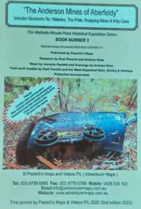
First book published: The Anderson Mines of Aberfeldy.
Every book published includes detailed maps and meticulously documented information. Each known mine along the route is named, mapped, and measured, with shafts carefully recorded — often with cross sections drawn to show their internal structure. The team cross-references historical photographs with present-day features to accurately locate and identify remnants of mining activity, tracks, and settlements. Old huts and their ruins are listed, and many are sketched or photographed in their current condition. Incredibly, some mines still bear the signatures of miners from over a century ago — and every one of these, along with other findings, is photographed and catalogued. This high level of documentation not only preserves the past but also allows for a direct connection between today’s explorers and the people who lived and worked in these remote, rugged landscapes.
Before any fieldwork begins, a new section is carefully chosen and undergoes extensive historical research, with many hours spent studying maps, mining records, land titles, and historical references — much of it sourced from the Public Record Office Victoria (PROV). These records help pinpoint the locations of forgotten infrastructure and the history of the people who once lived and worked in the area.
Members use GPS to plot tracks while walking their routes. Paul shared a funny story, joking that the GPS was really just to check up on them and make sure they were going where he wanted them to go!
Shamrock flume is a timber structure built in 1867, stretching nearly two miles through rugged terrain. Originally constructed to transport water for mining operations, the flume was a significant engineering feat of its time. While much of it has long since vanished into the landscape, recent efforts to locate its remains were successful. Using historical clues — including the known location of the Rose Company Hut chimney — they were able to pinpoint the likely alignment of the flume. After searching, a few remaining timbers were found, offering tangible evidence of this long-lost structure.
The Landy’s Cricket Ground at Shamrock, just off Binns Road, was discovered by members of the Aberfeldy Track Historic Touring Route, maintained by West Gippsland Inc. The find was significant because the ground had been largely forgotten over time, and its rediscovery helps preserve a unique piece of local sporting and community history from the region’s early settlement days.
A key part of the project’s success lies in the use of LiDAR (Light Detection and Ranging) technology, where scans taken from aircraft create highly detailed, three-dimensional maps of the landscape. These scans reveal historical features often hidden beneath dense bushland, such as pack tracks, tram tracks, water races, shafts, adits, and the remnants of old mining camps. The resulting maps are then uploaded into OziExplorer, a GPS mapping platform, making it possible to accurately plot the region to navigate and explore.
Kitty Bells Grave
An original hand-drawn map had once been given to Jeanette Rogers, leading to an in-depth research project into the burial site of Kitty Bell. According to historical records, Frederick Bell, originally from England, married Sarah Smith in 1867. After carefully studying the map and cross-referencing it with local knowledge and records, the site of their grave was eventually located. However, no headstone remained at the site — its absence suggested it may have been removed or lost over time. Supporting this theory was the discovery of a special edition Coca-Cola can near the location, which gave an approximate indication of when the site may have been disturbed or the headstone taken. Despite the missing marker, several relics were found around the grave site, further confirming its authenticity. In response, a new cross was made and installed to mark the spot. From the research conducted, it appears that Kitty was the child of Frederick and Sarah — likely born out of wedlock before their marriage in 1867.
Useful Links
- West Gippsland Relic, Mining and Heritage Protection Inc.: https://www.westgippslandinc.com.au/
- Adventurer Maps and Books: https://adventurermaps.com.au/